
1. INTRODUCTION
The Indonesian archipelago is located at the intersection of the Eurasian, Indo-Australian, and Pacific plates, forming an important component of the circum-Pacific tectonic belt (Pambudi, 2018). Plate convergence and subduction activities in this region provide the geodynamic conditions for the formation of deep heat sources and hydrothermal circulation. According to the Ministry of Energy and Mineral Resources (MEMR) of Indonesia (MEMR, 2025), the conventional geothermal resource potential of Indonesia is estimated to be approximately 23.7 GW to 27.0 GW, ranking among the highest in the world. In recent years, with the advancement of exploration and development, the installed geothermal capacity in Indonesia has shown a continuous growth trend. As of the end of 2025, Indonesia's total installed capacity reached approximately 2742 MW, ranking second globally (MEMR, 2025). Despite the high total installed capacity, the current actual development proportion accounts for only 10% to 11% of the resource potential, indicating significant room for deep exploitation and target area expansion in geothermal fields.
The variations in the spatial distribution, reservoir architecture, and thermophysical characteristics of Indonesian geothermal systems are controlled by the regional geodynamic setting (Setijadji, 2010; Nukman & Hochstein, 2019). Tectonically, the subduction geometry across different segments of the Sunda Arc influences the crustal stress state and magmatic activity of the overriding plate. Sumatra, affected by the oblique subduction of the Indo-Australian Plate, has developed the approximately 1900 km long Great Sumatran Fault (GSF) system, forming fault-controlled geothermal systems centered on strike-slip pull-apart basins and fracture networks (Sieh & Natawidjaja, 2000; Muraoka et al., 2010; Nukman & Hochstein, 2019). In contrast, subduction in West Java is near-orthogonal, characterized by a relatively thin crust and dispersed magmatic activity; here, geothermal fields are primarily associated with discrete andesitic volcanic complexes, exhibiting volcano-hosted characteristics (Setijadji, 2010). The differentiation of these tectonic and magmatic mechanisms controls the mechanical distribution patterns of reservoir permeability and fluid thermodynamic phases, resulting in the widespread occurrence of both liquid-dominated and vapor-dominated systems in Indonesia (Raharjo et al., 2016).
This study selects the fault-controlled geothermal systems in Sumatra (represented by Sipoholon and Sarulla) and the volcano-hosted geothermal systems in West Java (represented by Darajat) as comparative targets. By integrating regional geological settings with measured downhole temperature data, this paper primarily elucidates the genetic differences between the geothermal systems in these two regions from the perspectives of deep heat source evolution, reservoir architecture, and geochemical characteristics. This research aims to clarify the specific controls of different geodynamic settings on the key evolutionary elements of hydrothermal systems, thereby providing an objective theoretical reference for understanding the formation mechanisms and distribution patterns of geothermal fields in Indonesia and similar active tectonic belts.
2. GEOLOGICAL BACKGROUND OF INDONESIA
The Indonesian archipelago is located at the intersection of the Indo-Australian, Eurasian, and Pacific plates. Its regional geological evolution is dominated by continuous plate convergence and subduction that initiated in the Eocene (approximately 45 Ma) (Hall, 2012). These deep geodynamic processes formed the tectonic framework of the modern Sunda Volcanic Arc and provide basal heat flow and magmatic heat sources for regional geothermal systems (Hochstein & Sudarman, 2008; Ladiba et al., 2017).
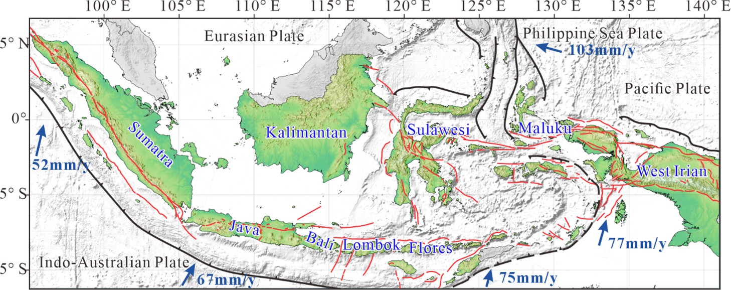
The Sunda Arc is the primary geological unit for the development of geothermal systems in Indonesia. Since the Early Miocene, the Indo-Australian Plate has been moving north and north-northeast at a relative rate of 63–70 mm/yr and subducting beneath the Sunda block (Bock et al., 2003; Hall et al., 2011). The spatial differentiation in the kinematic characteristics of this subduction zone leads to significant differences between Sumatra and West Java in terms of lithospheric thickness, fault development patterns, and magma underplating mechanisms (McCaffrey, 2009).
In Java and the regions to its east, plate convergence approaches orthogonal subduction (Figure 1). The subducting slab penetrates into the lower mantle with a dip angle of approximately 49–56° (Widiyantoro & van der Hilst, 1997; Hayes et al., 2018). Due to the weak lateral shear stress component of the orthogonal plate convergence, the tectonic stress is primarily released through decompression melting triggered by fluid metasomatism in the mantle wedge, vertical underplating of deep magma, and frequent shallow volcanic activity (Kopp et al., 2002; Setijadji et al., 2006; Handley et al., 2007). This stress release mode has resulted in the absence of large-scale strike-slip fault zones traversing the entire island in West Java. Instead, the region is primarily controlled by secondary micro-fracture networks derived from local extensional stress and concealed ring structures. Conversely, the subduction beneath Sumatra is characterized by oblique subduction (Figure 1) (McCaffrey, 2009). The angle between the plate motion vector and the trench strike generates trench-parallel shear strain in the forearc and intra-arc regions. Strain partitioning at the margin of the Eurasian Plate induced the development of the approximately 1,900 km long Great Sumatran Fault (GSF) system (Sieh & Natawidjaja, 2000). As an active dextral strike-slip fault, the Late Quaternary slip rate of the GSF exhibits spatial variations; for instance, it is approximately 23 ± 3 mm/yr near the Tor Sibohi fault segment. In regions of fault strike deflection or right-stepping offsets during the strike-slip process, local kinematic discontinuities induce extensional stress, which in turn controls the formation of pull-apart basins and half-graben structures, such as the Sarulla Graben, Tarutung Basin, and Hululais Basin (Bellier & Sébrier, 1994). These fault-controlled basin systems are not only accompanied by local crustal thinning but also provide conduits for the deep circulation of geothermal fluids and magma emplacement (Muraoka et al., 2010).
Crustal thickness and material composition influence the evolutionary trajectory of mantle-derived magma during its ascent, thereby dictating the physicochemical properties of the heat source. Sumatra is situated at the margin of relatively thick continental crust, with a crustal thickness ranging from 30 km to 40 km, and its basement is primarily composed of Late Paleozoic metasedimentary rocks of Sundaland (Barber et al., 2005). The thicker continental crust increases the lithostatic pressure and buoyancy barriers for magma ascent, leading basaltic mantle-derived magma to experience a prolonged residence time in the lower or middle crust. During this period, assimilation and fractional crystallization drive the magma to evolve toward a more felsic composition, favoring the formation of highly evolved, volatile-rich silicic intrusions (Chesner, 1998). Such deep silicic magma chambers are characterized by long cooling periods and stable heat flux release, providing long-term basal heat flow for the pull-apart basins along the GSF (Hochstein & Sudarman, 2008). In contrast, West Java exhibits a transitional island arc environment with a thinner crust of approximately 20 km to 25 km (Kopp et al., 2002). The shortened magma ascent conduits reduce the intra-crustal residence time and the degree of crustal assimilation. Consequently, the volcanic eruptive products in West Java are predominantly intermediate-mafic lavas and pyroclastic rocks. The heat sources are characterized by smaller individual scales but dense spatial distributions, forming numerous moderate-volume shallow magma chambers. This deep material foundation causes the geothermal systems in West Java to primarily associate with local, shallow andesitic volcanic complexes, exhibiting a clustered spatial distribution.
3. HEAT FLOW CHARACTERISTICS AND GEOTHERMAL RESOURCE POTENTIAL
3.1. Terrestrial heat flow and heat sources
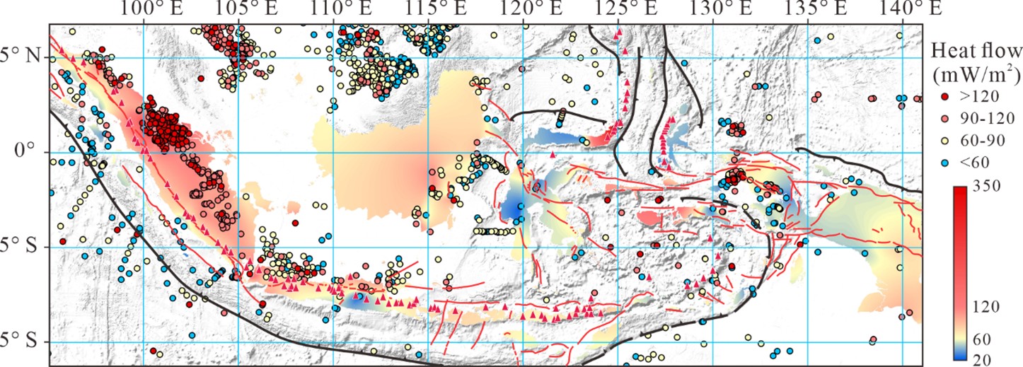
Overall, the Sunda Volcanic Arc exhibits high background heat flow, driven by plate-margin dynamics and magma underplating. The global terrestrial heat flow database (Figure 2) indicates that terrestrial heat flow along the West Java and Sumatra volcanic arcs is generally elevated. Around the concealed fault zones and volcanic complexes in West Java, local peak terrestrial heat flow values can reach 186.5 mW/m2, significantly higher than the global continental crust average background value of approximately 65 mW/m2 (Siringoringo et al., 2025). For Sumatra, joint gravity and magnetic inversion data indicate that high heat flow anomalies exhibit a linear or beaded distribution along the Great Sumatran Fault (GSF) and Quaternary volcanic centers. Characteristics of the deep magnetic basement reveal that intrusive bodies with a density of approximately 2.8 g/cm3 are distributed at depths of 7 km and below, providing a sustained heat source for the overlying fault zones and hydrothermal systems (Mustika et al., 2023). In this context, the heat sources of the geothermal systems are primarily controlled by shallow (a few kilometers deep) high-temperature magma chambers or subvolcanic intrusions. Magmatic bodies with initial temperatures of approximately 800–1100 °C heat the overlying bedrock via thermal conduction, driving groundwater to form convective circulation within shallow brittle fracture zones.
3.2. Distribution of geothermal systems
According to the geothermal play type classification by Moeck (2014), the high-temperature geothermal systems of the Sunda Volcanic Arc primarily belong to convection-dominated magmatic systems. In such systems, heat is transported by fluids migrating upward along high-permeability conduits to shallow reservoirs. In terms of spatial distribution, differences in the stress fields across various segments of the volcanic arc have led to the differentiation of the hosting architectures of geothermal fields. In Sumatra, the spatial distribution of geothermal systems is highly constrained by the GSF. Thirteen large pull-apart basins developed along this strike-slip fault zone have provided eruptive conduits for Quaternary volcanoes (Muraoka et al., 2010). Under continuous transtensional processes, the boundary normal faults of the basins remain open, forming permeable conduits for deep fluid circulation, which results in the linear distribution of geothermal fields along the fault zone. In West Java, however, affected by orthogonal subduction, strike-slip faults are poorly developed, and magma primarily ascends along local extensional fractures or caldera ring faults. For example, the Garut ring structure zone resulted from the evacuation of the magma chamber and subsequent roof collapse following early volcanic eruptions. Such ring collapse structures and their associated radial fracture networks provide three-dimensionally interconnected hosting space for deep fluids. These diffuse secondary fracture networks cause the West Java geothermal systems to be primarily associated with large stratovolcanoes (e.g., the Kendang and Papandayan complexes), exhibiting a clustered distribution.
4. FAULT-CONTROLLED GEOTHERMAL SYSTEMS IN SUMATRA
Sumatran geothermal systems are typical representatives of fault-controlled hydrothermal systems globally. Their reservoir architecture is controlled by the geometry of strike-slip faults, and the mechanisms of fluid recharge, migration, and discharge are closely related to the kinematic evolution of the fault zones. Taking the Sipoholon geothermal field in the Tarutung Basin and the Silangkitang geothermal field in the Sarulla Graben as examples, this section elucidates the physicochemical characteristics of such systems.
4.1. Kinematic characteristics of the GSF
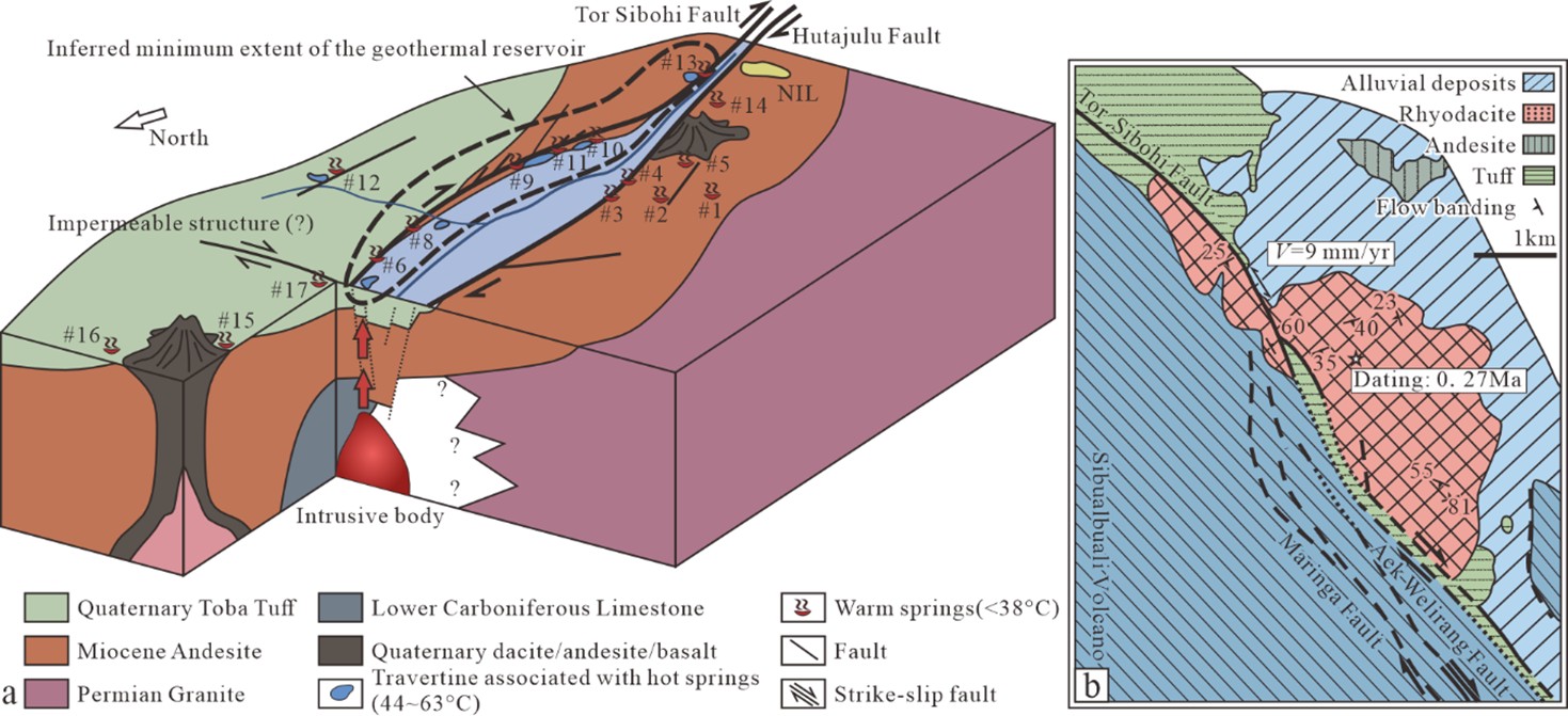
Sumatra is located at the southern margin of the Eurasian Plate, and its basement is composed of Late Paleozoic metasedimentary rocks of Sundaland (Barber et al., 2005). Under the background of oblique plate subduction, the Great Sumatran Fault (GSF) evolved as the principal fault accommodating crustal shear strain (Sieh & Natawidjaja, 2000). Under the dextral strike-slip mechanism, fault strike deflections or step-overs have developed multiple pull-apart basins (such as the Sarulla Graben and the Tarutung Basin) (Muraoka et al., 2010). Previous studies suggest that the boundary normal faults and transtensional zones of the pull-apart basins provide space for deep magma intrusion, enhance the secondary permeability of the shallow crust, and construct conduits for the convective circulation of hydrothermal fluids (Figure 3a) (Nukman & Moeck, 2013). The shear deformation of the fault system undergoes strain partitioning on a geological time scale (McCaffrey, 2009). Kinematic investigations indicate that in the Sarulla region (Figure 3b), based on the offset distance of the 0.27 ± 0.03 Ma Tor Sibohi rhyodacite dome, the Late Quaternary slip rate of the main Tor Sibohi Fault (TSF) segment is estimated to be approximately 9 mm/yr (Hickman et al., 2004). This value is lower than the regional average slip rate (25–30 mm/yr), indicating that local shear strain has been accommodated by the complex strike-slip and extensional fault networks within the basin (Sieh & Natawidjaja, 2000; Hickman et al., 2004).
4.2. Sipoholon geothermal field
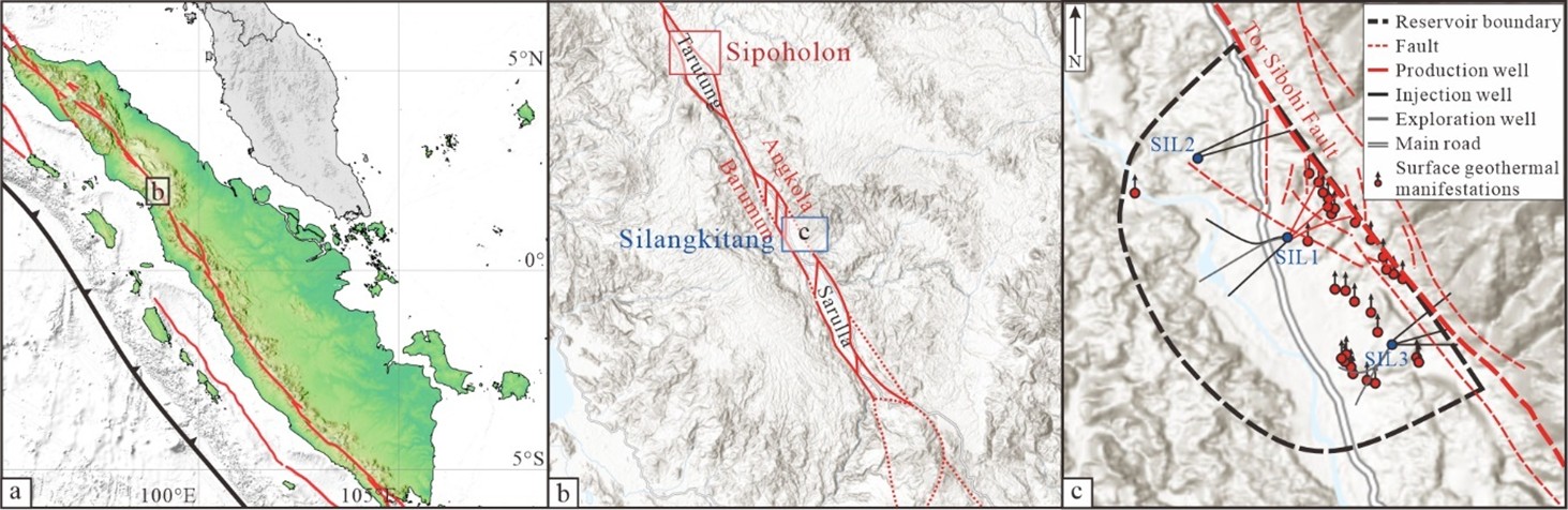
The Sipoholon geothermal field is located in the Tarutung pull-apart basin, North-Central Sumatra, and is controlled by local transtensional structures of the GSF (Figure 4a, 4b). Unlike geothermal systems at massive volcanic centers, its deep heat source is driven by tectonic heat flow and deep-seated blind magmatic intrusions within a strike-slip transtensional framework, rather than conductive heat transfer from adjacent dormant volcanoes (Nukman & Hochstein, 2019). Magnetotelluric (MT) profiles reveal a deep-reaching low-resistivity body (<10 Ω·m) beneath the Panabungan normal fault zone east of the Tarutung Basin. This vertical conductive channel is interpreted as a migration pathway for deep thermal fluids upwelling along principal faults. At depths of 1–2 km, MT reveals a horizontal low-resistivity layer (~2 Ω·m), defining a brine-rich primary reservoir; shallow Quaternary tuffs locally function as an aquiclude (Niasari, 2015).
Fluid geochemical characteristics corroborate the mechanism of fault-controlled fluid circulation. The region features 18 surface thermal manifestations, accompanied by large-scale white travertine deposits. Hydrochemical types are predominantly CO2-rich Ca-SO4-HCO3 or Cl-SO4-HCO3 (Muraoka et al., 2010; Nukman, 2014). Stable isotope (δ18O and δD) analysis indicates that meteoric recharge accounts for approximately 90% of the fluid, while magmatic degassing contributes roughly 10% (Nukman, 2014). SiO2 geothermometry estimates surface fluid temperatures at 50–80 °C and deep reservoir temperatures at 190–225 °C (Nukman, 2014). These hydrochemical zonations and isotopic shifts identify Sipoholon as a fault-constrained, medium-to-high temperature hydrothermal system.
Hydrogeologically, Sipoholon can therefore be regarded as an open, fault-controlled groundwater-flow system. The high proportion of meteoric water indicates recharge from topographically higher areas around the Tarutung Basin, whereas the deep low-resistivity conduit and the 1–2 km brine-rich reservoir suggest downward circulation along fault-damage zones followed by thermal upflow along the principal structures (Niasari, 2015; Nukman & Hochstein, 2019). In this setting, the hydraulic-head gradient is mainly controlled by basin relief and fault permeability, and pore pressure is likely buffered by continuous recharge and discharge rather than by long-term hydraulic sealing (Ingebritsen et al., 2006; Nukman, 2014).
4.3. Silangkitang geothermal field
Influenced by magmatic intrusions beneath adjacent large Quaternary volcanic centers, the Sarulla geothermal block possesses abundant geothermal resources and has currently become one of the largest geothermal power projects globally (Hickman et al., 2004). Controlled by the GSF, the Sarulla geothermal block extends in a NW-SE direction, successively developing four geothermal fields from northwest to southeast: Namora-I-Langit, Silangkitang, Donotasik, and Sibualbuali (Gunderson et al., 2000; Iqbal & Sabrian, 2023). Among them, Namora-I-Langit and Silangkitang (SIL) are the core production areas, currently with a combined installed capacity exceeding 330 MW.
The eastern boundary of the SIL geothermal field is controlled by the Barumun Fault, and the western boundary is defined by the Angkola Fault (Figure 4b). The two principal faults bifurcate here, inducing extensional stress at their terminations and shaping the tectonic morphology of the Sarulla Graben (Hickman et al., 2004; Abiyudo et al., 2021). The southern segment of the Barumun Fault evolves into the Tor Sibohi Fault (TSF). The hydrothermal system within the SIL target area is primarily controlled by the TSF and its western subsidiary fault (WTSF) (Figure 4c). High-permeability zones are predominantly hosted within the tectonic fracture zones between the faults (Gunderson et al., 2000; Satya et al., 2021), and the primary reservoir is the tuff formation within the graben (Abiyudo et al., 2021; Satya et al., 2021).
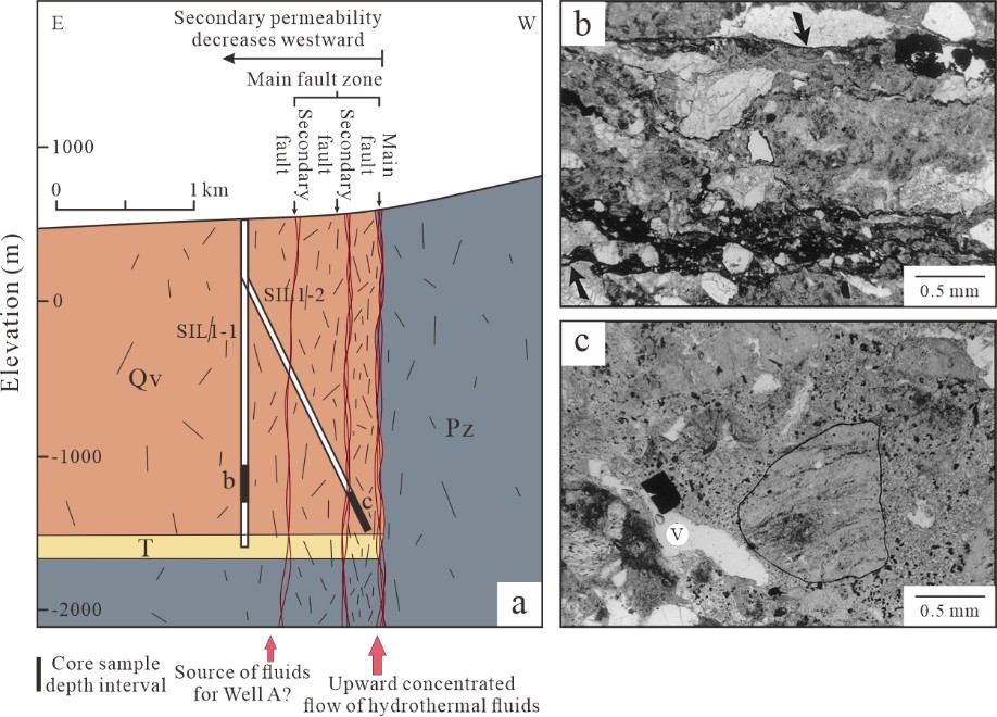
The SIL reservoir exhibits typical high-temperature hydrothermal characteristics, with measured temperatures exceeding 280 °C and maximum local bottom-hole temperatures reaching up to 327 °C, while the reservoir fluids display low to moderate gas contents (<1 wt%) (Gunderson et al., 2000). Subjected to hydrothermal alteration, the shallow strata have developed a smectite-dominated low-resistivity clay cap ranging from 0.5 to 1.5 km in thickness, effectively maintaining reservoir pressure (Nukman & Hochstein, 2019). Downhole temperature profiles indicate that the geothermal gradient in the overlying caprock section is as high as 170–290 °C/km, representing the typical thermophysical characteristics of a conductive caprock (Figure 5). In contrast, the geothermal gradient in the reservoir section drops abruptly to 50–90 °C/km, likely caused by vigorous convective circulation of high-temperature fluids within the fault fracture zone (Dwi Marjuwan et al., 2016; Satya et al., 2021). Furthermore, the temperature inversion feature observed in the shallow section of the directional well SIL3-1 potentially indicates the localization and heterogeneity of fluid activity under fault control. This observation is consistent with the study by Moore et al.(2001) on microstructures within fault zones, which suggested that, driven by spatial variations in secondary permeability, high-temperature fluids exhibit localized channeled flow at fault margins (Figure 6a). The temperature anomaly captured by SIL3-1 may be a direct physical manifestation of such lateral advection phenomena, reflecting the function of the fault fracture zone as a transient fluid migration pathway.
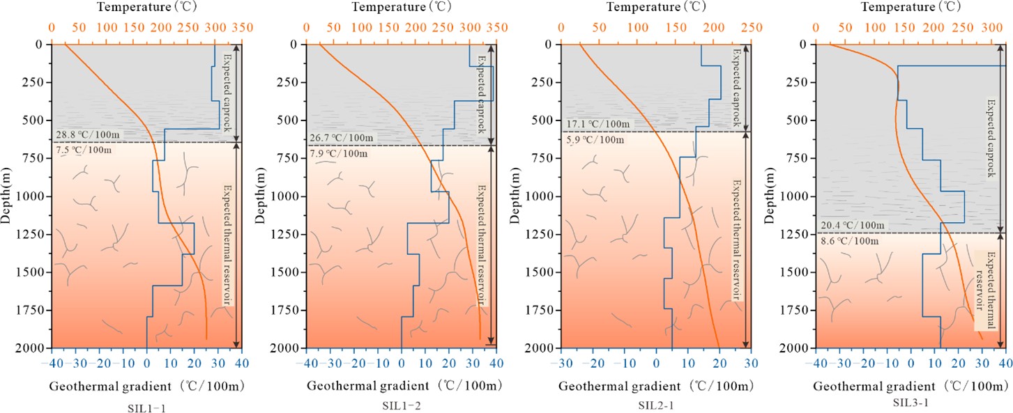
Vertically, the geothermal gradient profiles of SIL1-1, SIL1-2, and SIL3-1 all exhibit an alternating pattern of "increase-decrease-increase-decrease", revealing the vertical development of multiple stacked permeable fracture zones within the reservoir rather than a homogeneous convective body. The convective intervals characterized by low geothermal gradients lithologically correspond to the high-porosity breccia zones and hydrothermal minerals growing within open fractures as recorded by Moore et al.(2001). In contrast, the conductive intervals where the geothermal gradient increases correspond to permeability barriers formed by densification (Figure 6b, 6c). The coupling of geophysical logs and mineralogical records confirms a complex multilayered thermodynamic structure within a single tectonic framework.
The hydraulic architecture of Silangkitang is more compartmentalized than that of a single homogeneous reservoir. The smectite-dominated clay cap can reduce vertical leakage and help maintain reservoir pressure, whereas the Tor Sibohi Fault and its subsidiary faults provide laterally connected high-permeability pathways for liquid-dominated convection (Gunderson et al., 2000; Grant & Bixley, 2011; Satya et al., 2021). The repeated alternation between high- and low-gradient intervals in the wells is consistent with stacked hydraulic units, in which permeable fracture intervals display pressure and temperature communication, whereas denser altered intervals act as partial hydraulic barriers.
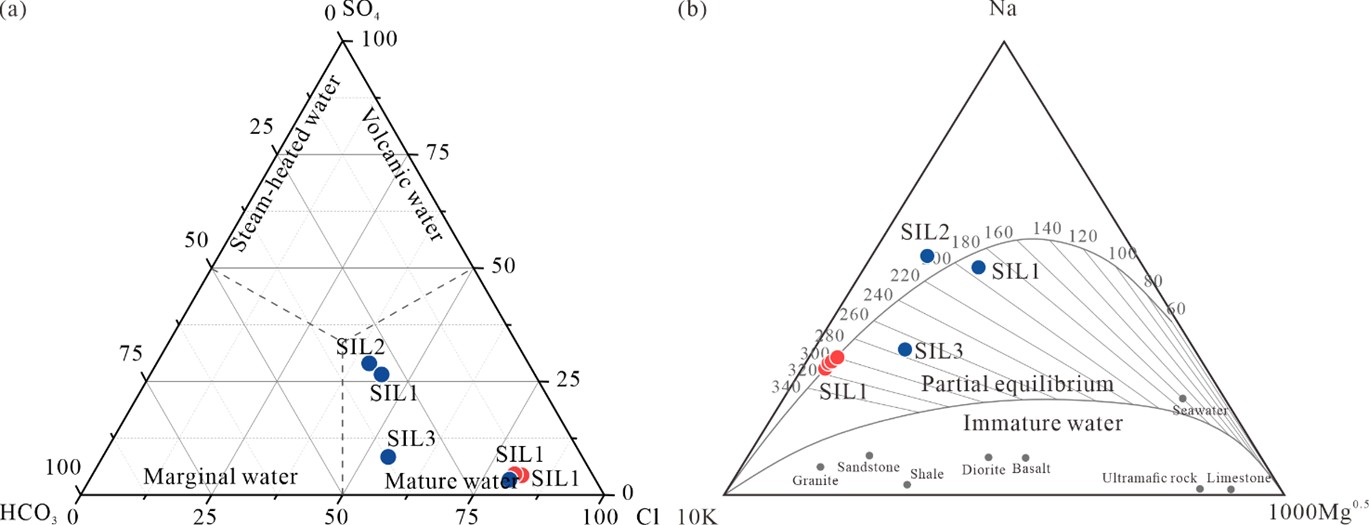
Fluid geochemical characteristics indicate that the core area primarily produces mature chloride geothermal water, and the Na-K-Mg triangular diagram demonstrates that it has reached full thermodynamic water-rock equilibrium (Figure 7) (Simatupang et al., 2020). The very low Mg²⁺ concentration in the core area fluids indicates that Mg has completely precipitated into secondary alteration minerals during the deep high-temperature circulation process. Notably, the Cl- concentration of the fluids in this core area is relatively low (<1000 ppm), which is primarily controlled by two factors: first, the lack of an initial chlorine-rich material supply from the metamorphic basement; and second, the introduction of deep circulation of abundant chlorine-depleted meteoric water through the open boundaries of the fault zone, resulting in a significant dilution effect (Simatupang et al., 2020). In contrast, in the marginal zones of the hydrothermal system, due to the lateral influx of colder shallow groundwater, the fluids exhibit a distinct mixing evolutionary trend. The mixing of cold water not only further dilutes and reduces the Cl- concentration but also leads to a characteristic increase in the Mg2+ concentration within the fluids, as the cold water has not undergone high-temperature alteration and precipitation (Giggenbach, 1988; Nicholson, 1993).
5. VOLCANO-HOSTED GEOTHERMAL SYSTEMS IN WEST JAVA
Geothermal systems in the West Java region are primarily controlled by the volcanic arc and back-arc extensional tectonic framework induced by the subduction of the Indo-Australian Plate beneath the Eurasian Plate; this geodynamic setting determines the present-day high heat flow distribution characteristics. Taking the West Java Basin as an example, the geothermal field in this region exhibits significant spatial heterogeneity. Under the combined influence of deep magmatic evolution and local concealed fault systems, the geothermal gradient in non-tectonically active areas mostly ranges from 37.0 to 66.0 °C/km, with terrestrial heat flow between 60.8 and 140.0 mW/m2; whereas near Quaternary volcanic centers or extensional boundaries, local peak heat flow can reach 186.5 mW/m2, with geothermal gradients exceeding 120.0 °C/km (Suryantini et al., 2006; Putra et al., 2016). Under the dual control of geological structures and deep heat sources, abundant geothermal resources are enriched along West Java. According to the assessment by the Ministry of Energy and Mineral Resources of Indonesia, as of 2025, the proven geological reserves of Java Island reach 1765 MW, primarily concentrated in core regions where large faults intersect with volcanic complexes, such as Darajat, Kamojang, and Wayang Windu (MEMR, 2025).
5.1. Tectonic framework and deep magmatic processes
Distinct from the linear distribution along the Great Sumatran Fault (GSF) in Sumatra, geothermal systems in the West Java region predominantly exhibit a clustered distribution. Their heat occurrence is controlled by deep concealed regional tectonic systems and local Quaternary volcanic centers (Ladiba et al., 2017). In terms of the macroscopic tectonic setting, Java Island is located at the active margin of the orthogonal subduction of the Indo-Australian Plate beneath the Eurasian Plate. Compared to the oblique subduction in Sumatra, the subducting slab beneath West Java has a steeper dip angle. The tectonic stress of orthogonal convergence is primarily released through partial melting of the mantle wedge, deep magma underplating, and high-frequency volcanic activity (Hall, 2012; Ladiba et al., 2017).
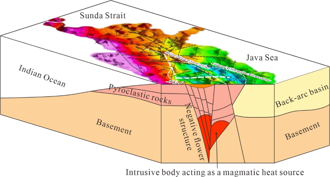
Based on the 3D inversion of regional Bouguer gravity anomaly data, a large NW-SE trending concealed fault zone in West Java and several large ring structures (e.g., the Garut ring structure) can be identified (Figure 8) (Fauzi et al., 2015). Although these deep basement structures lack large-scale horizontal strike-slip displacement similar to the GSF, they provide conduits for the vertical emplacement of deep magma. This facilitates the high concentration of volcanoes and geothermal fields along zones of structural weakness, forming large-volume magma chambers in the shallow crust (Figure 8) (Fauzi et al., 2015; Arisbaya et al., 2023). The Garut ring structure zone hosts five globally rare vapor-dominated systems. The Darajat geothermal field is one of these five systems within the Garut ring structure zone and is currently the largest vapor-dominated geothermal field in Indonesia. Kinematic analysis indicates that West Java as a whole is situated within a local extensional stress field trending NNW-SSE to NNE-SSW. Due to the lack of a strike-slip shear system traversing the entire region, the superimposition of the regional extensional setting and the thermal stress generated by frequent magma intrusions has led to the development of dense micro-fracture networks within the thick andesitic lavas and pyroclastic rocks (Rejeki et al., 2010). The bedrock micro-fracture system, controlled by extensional stress, enhances the overall secondary permeability of the strata, constituting the typical volcano-hosted geothermal reservoir architecture in West Java (Bogie & Mackenzie, 1998; Utami, 2000).
5.2 Darajat geothermal field
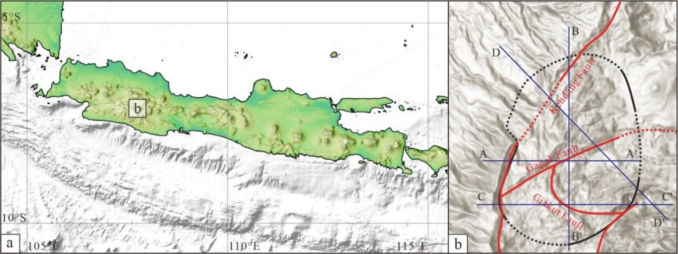
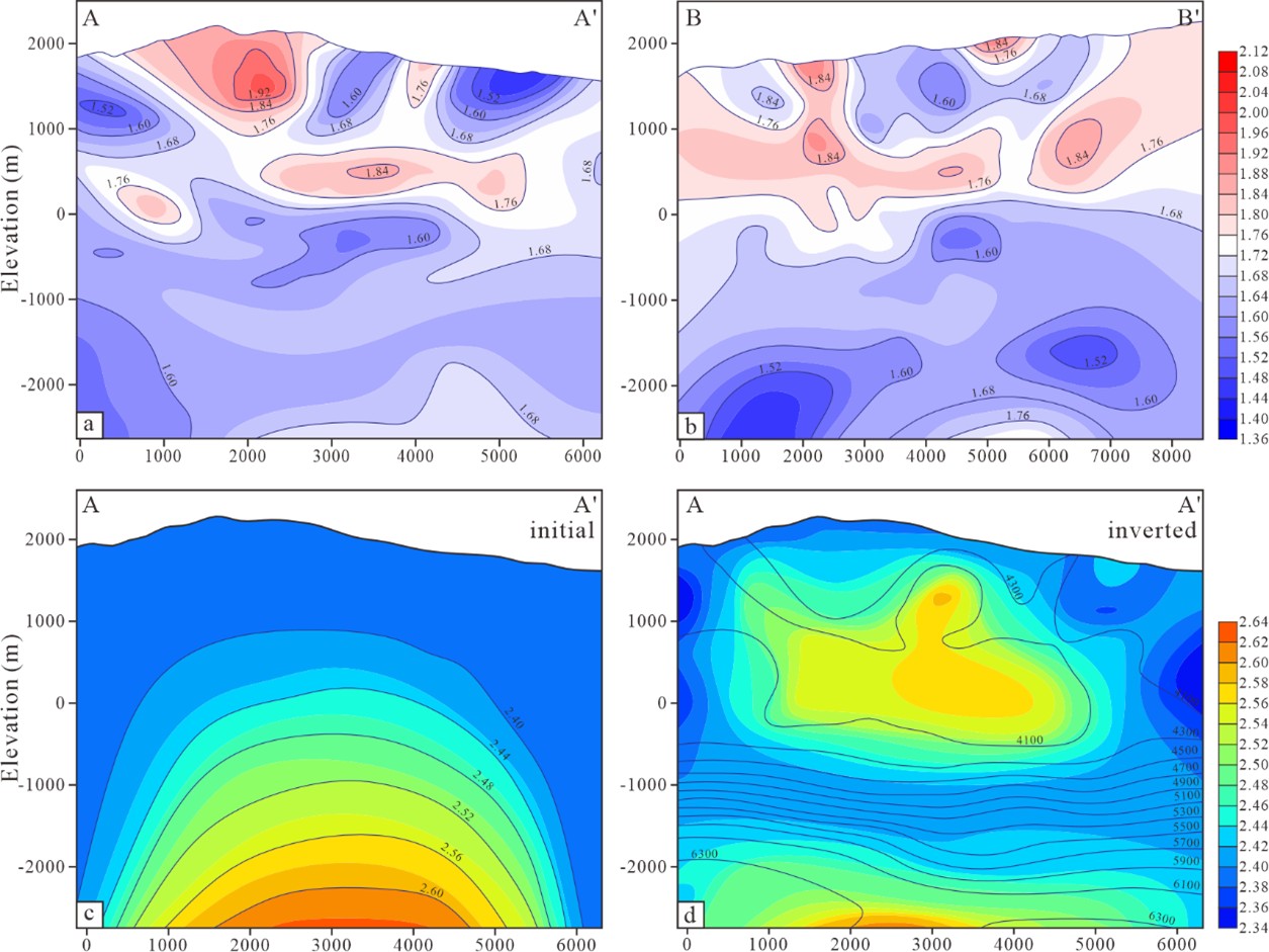
Shallow magma chambers and regional extension-derived micro-fracture networks collectively nurture the vapor-dominated geothermal clusters in West Java (Hochstein & Sudarman, 2008). Taking the Darajat geothermal field as an example, its evolution depends on the coupling of deep reservoir-forming elements (Rejeki et al., 2010). The field is located within the Kendang volcanic complex and is tectonically controlled by several major faults (Figure 9), including the Kendang and Gagak faults (Hadi, 2001; Rejeki et al., 2010). Geophysical exploration reveals high-density and high Vp/Vs anomalies at depth (burial depth >4 km) (Figure 10), indicating the presence of a Pleistocene andesitic magmatic intrusion within the complex, which provides a stable basal heat source for the system (Julian et al., 2010; Soyer et al., 2018). Driven by deep heat flow, high-temperature fluids migrate vertically along NE-SW and NW-SE trending concealed fault zones (Rejeki et al., 2010; Sapiie et al., 2017).
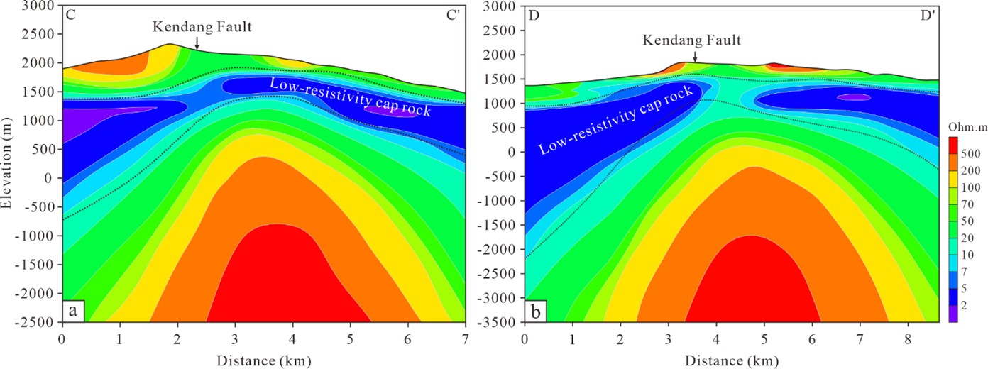
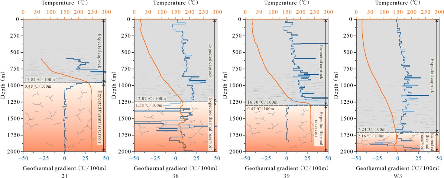
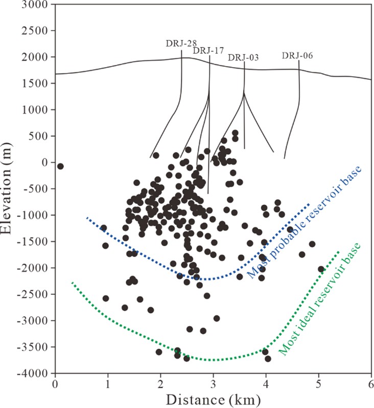
High-temperature fluids are primarily hosted within thick andesitic lavas above the magmatic intrusion (Hadi, 2001). At the top and periphery of the reservoir, hydrothermal alteration by acidic fluids and meteoric water has formed a thick smectite-rich argillic zone (Soyer et al., 2018). This alteration zone manifests as a typical shallow low-resistivity anomaly on magnetotelluric profiles (Figure 11), constituting a low-permeability domal clay cap. This cap maintains the relative closure of the geothermal field and inhibits the large-scale influx of external cold water (Rejeki et al., 2010; Soyer et al., 2018). Temperature profiles show non-linear upward convex characteristics in the caprock section (Figure 12), where the geothermal gradient gradually increases with depth, reaching 70–180 °C/km near the bottom boundary of the caprock (Intani et al., 2015). This transient thermophysical response may be controlled by two factors: first, tectonic micro-fractures leading to minor vertical leakage of deep fluids, which introduces a convective heat transfer component (Bredehoeft & Papaopulos, 1965); and second, the condensation of upwelling steam at the base of the caprock releasing latent heat of phase change, resulting in local heat accumulation (Rejeki et al., 2010). Upon entering the deep reservoir section (below 500–1200 m) (Figure 12), the geothermal gradient decreases to 0.4–2.2 °C/100m (Intani et al., 2015). This near-isothermal characteristic likely indicates the development of gas-liquid two-phase thermal convection circulation within the reservoir, where efficient convective heat transfer homogenizes the internal temperature field (White et al., 1971). The spatial distribution of micro-earthquakes (MEQ) (Figure 13) suggests that micro-fracture zones developed along concealed structural planes constitute the skeletal network for fluid convection, with high-permeability zones extending downward to approximately 4–5 km below sea level (Soyer et al., 2018). The overall permeability of the system decreases with depth, and the primary production zones are concentrated between elevations of 200 and 800 m (Rejeki et al., 2010).
The pore-pressure regime of Darajat differs from the open fault-controlled systems in Sumatra. Because the argillic cap restricts external groundwater recharge, the reservoir does not maintain a fully hydrostatic liquid column; instead, sustained boiling and steam production favor a pressure-depleted vapor-dominated zone beneath the low-permeability cap (White et al., 1971; Ingebritsen & Sorey, 1988; Raharjo et al., 2016). The hydraulic-head framework is therefore dominated by internal steam upflow, local condensation at the base and margin of the caprock, and gravity-driven condensate reflux, rather than by large-scale throughflow of cold meteoric water (Hadi, 2001; Rejeki et al., 2010; Intani et al., 2020).
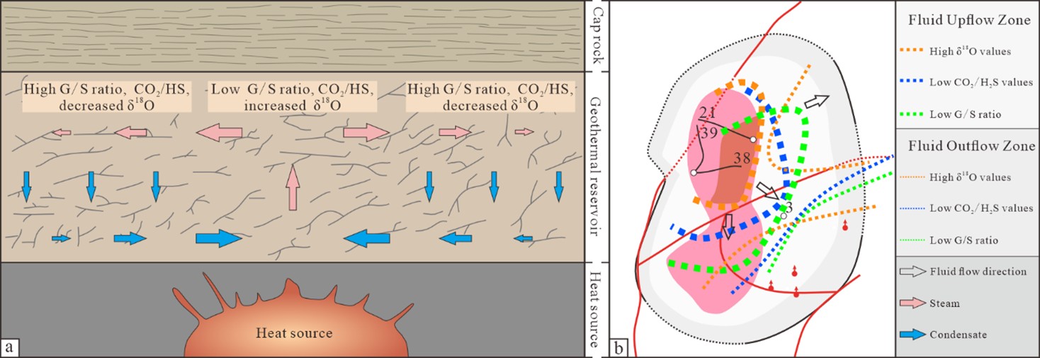
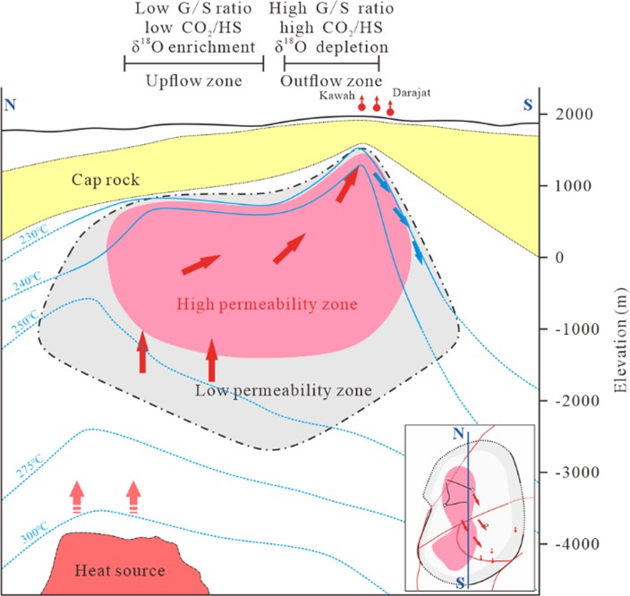
The Darajat geothermal fluid circulation exhibits a typical vapor-dominated mode (Hadi, 2001; Intani et al., 2020). Phase separation occurs within the reservoir, where the upward steam flux and limited downward liquid reflux collectively maintain a state of continuous boiling (White et al., 1971; Rejeki et al., 2010). Fluid geochemical characteristics during the early development stage objectively recorded this solubility-controlled phase change evolutionary sequence (Intani et al., 2020). As deep steam migrates laterally from the central upflow zone toward the margins, local condensation occurs due to heat loss to the surface, causing soluble components to preferentially enter the liquid phase (Figure 14) (D’Amore & Truesdell, 1979; Hadi, 2001). This condensation process generates a clear spatial zonation: with increasing distance from the upflow zone, the gas/steam and CO2/H2S ratios show an upward trend, while the δ18O isotopes in the residual gas phase exhibit continuous depletion (Figure 14). The contours of these geochemical indicators not only delineate the central upflow zone of the geothermal field, but their decaying gradients toward the periphery also confirm the kinetic process of lateral steam diffusion (Hadi, 2001; Intani et al., 2020). In summary, Darajat forms a convective cell enclosed by a low-permeability alteration zone. The deep heat source drives fluid upwelling along fracture zones to the shallow section (condensation boundary ~200 °C), where some steam escapes, and the condensed liquid phase is gravity-driven to reflux back to the depths for reheating (Figure 15).
6. DISCUSSION
6.1. Subduction zone geometry and deep heat source evolution
A comparison between Sumatra and West Java indicates that the geometrical characteristics of plate subduction (oblique versus orthogonal) and variations in crustal thickness control the evolutionary trajectories of deep magma and the distribution patterns of heat flux (Ladiba et al., 2017). Sumatra possesses a relatively thick continental crustal basement (approximately 30–40 km), which subjects mantle-derived underplated magma to significant assimilation and fractional crystallization during its ascent (Chesner, 1998; Barber et al., 2005). This process tends to form large-volume silicic intrusions characterized by high degrees of evolution and long cooling periods. Such concealed magmatic intrusions provide long-term stable basal heat flow for the pull-apart basins along the GSF (e.g., the Sarulla geothermal field) (Ladiba et al., 2017; Abiyudo et al., 2021). In contrast, West Java represents a transitional thin-crust island arc environment with shorter magma ascent conduits and a lower degree of crustal contamination, predominantly developing intermediate-mafic (basaltic-andesitic) stratovolcano complexes (Smyth et al., 2008). Its heat sources are characterized by limited individual scale but dense spatial distribution, causing the geothermal systems in this region to primarily associate with local shallow volcanic complexes, exhibiting a clustered distribution (Raharjo et al., 2016).
6.2. Coupling Models of Tectonic Stress Fields and Reservoir Permeability
Regarding the formation mechanisms of reservoir permeability structures, Sumatra and West Java exhibit differentiated tectonic-fluid coupling patterns controlled by their regional settings. Deep fluid upwelling in both regions relies on principal fault systems, but they present different characteristics in the spatial topology of permeability at the reservoir scale (Rowland & Sibson, 2004; Moeck, 2014). Fluid migration in Sumatran geothermal systems is highly controlled by the regional strike-slip shearing of the Great Sumatran Fault (GSF). Large-scale strike-slip step-overs and associated normal faults constitute vertical conduits for deep circulation, concentrating high-permeability zones within fault cores and damage zones (Muraoka et al., 2010; Natawidjaja, 2018). This "fault-controlled" mechanism constrains the spatial distribution of geothermal systems to a corridor-like pattern. In contrast, West Java systems belong to the "coupled local structure and volcanic facies" type. Under the orthogonal subduction background, this region lacks large-scale strike-slip corridors traversing the entire area, and the primary controlling factors shift to local extensional fault systems (Clements & Hall, 2007). The superimposition of regional extensional stress, thermal stress generated by frequent shallow magma intrusions, and cooling contraction induces a more diffuse secondary micro-fracture network within the thick andesitic lava and pyroclastic basement (Stimac et al., 2015). This mechanism causes the shallow permeability architecture of West Java geothermal fields to exhibit volume-hosted characteristics, providing the fluid circulation pathways within the reservoir with a higher dimensionality of spatial connectivity (Raharjo et al., 2016).
6.3. Thermodynamic mechanisms of fluid phase and hydrothermal system type evolution
Differences in the geological tectonic framework and permeability architecture govern the differentiation and evolutionary trajectories of deep fluid phases within hydrothermal systems (Hochstein & Sudarman, 2008). Due to the development of strike-slip fault zones penetrating to the surface, the pull-apart basins in Sumatra possess relatively open hydrogeological boundary conditions (Curewitz & Karson, 1997). These high-permeability fault corridors readily receive abundant meteoric water for both lateral and vertical recharge (Muraoka et al., 2010). Regarding fluid mass balance, the recharge rate is sufficient to offset or exceed the system's discharge rate. The deep heat flux is efficiently absorbed by the continuous influx of liquid water, forming vigorous liquid-phase thermal convection within the fault zone. Macroscopically, this tends to evolve into liquid-dominated, medium-to-high temperature hydrothermal systems (Curewitz & Karson, 1997; Moeck, 2014).
In contrast, certain geothermal systems in West Java (e.g., Darajat and Kamojang) evolve into vapor-dominated systems. The thermodynamic mechanism lies in specific reservoir-caprock assemblages that reshape the mass and energy balance of the system (Allis, 2000). Long-term hydrothermal alteration by acidic gases and meteoric water forms dense, low-resistivity smectite-rich argillic zones at the top of the andesitic volcanic rocks (Utami, 1999; Cumming, 2016). This continuous, low-permeability clay cap constitutes a restricted hydrological boundary, effectively suppressing the fluid mass exchange rate between the reservoir and the external environment (Ingebritsen & Sorey, 1988). Under this closure mechanism, the long-term escape of high-temperature steam to the shallow depths exceeds the lateral recharge of peripheral cold water. Under the combined effects of sustained deep high heat flux and net mass deficit, the reservoir interior undergoes long-term pressure drawdown and deep phase separation (boiling), thereby establishing and maintaining a vapor-dominated convective circulation phase (White et al., 1971; Scott et al., 2015).
Although direct hydraulic-head and pore-pressure measurements are not uniformly available for all selected geothermal fields, the available indirect constraints support a consistent hydrogeological interpretation. In Sumatra, meteoric-water recharge, mature chloride waters, low geothermal gradients within reservoir intervals, and fault-centered permeability indicate an open recharge-discharge system with pressure-buffered liquid convection. In West Java, the low-resistivity clay cap, restricted recharge, boiling, steam upflow, condensation, and condensate reflux indicate a more closed hydraulic architecture in which pressure drawdown contributes to the maintenance of vapor-dominated convection (Ingebritsen & Sorey, 1988; Grant & Bixley, 2011; Raharjo et al., 2016). Thus, groundwater-flow conditions and pore-pressure regimes provide an additional constraint on the genetic distinction between fault-controlled liquid-dominated systems in Sumatra and volcano-hosted vapor-dominated systems in West Java.
7. CONCLUSIONS
Through a systematic comparison of typical geothermal fields in Indonesia, this study clarifies that the genetic differences of geothermal systems in this region are controlled by regional geodynamic processes, leading to the following conclusions:
(1) The oblique subduction and thick continental crustal basement in Sumatra promote assimilation and fractional crystallization of underplated magma, forming large-volume silicic concealed magma chambers with long cooling periods. The orthogonal subduction and transitional thin-crust environment in West Java shorten the magma ascent conduits, predominantly developing intermediate-mafic shallow volcanic complexes, with heat sources exhibiting a spatially limited individual scale but a discrete and dense distribution.
(2) Fluid migration in Sumatran geothermal systems is controlled by the strike-slip shear mechanism of the Great Sumatran Fault. High-permeability zones are concentrated within the principal faults and their strike-slip step-overs, resulting in a "fault-controlled" linear corridor-like distribution of the systems. In West Java, under the superimposition of local extensional stress and magmatic thermal stress, diffuse secondary micro-fracture networks are derived within the thick andesitic basement, presenting a "volume-hosted" spatial architecture with higher connectivity.
(3) The surface-penetrating faults developed in Sumatran pull-apart basins provide open fluid recharge boundaries, causing the systems to tend toward a liquid-dominated thermal convection mode. In contrast, the tops of certain systems in West Java have developed dense, low-permeability clay caps due to hydrothermal alteration, constituting restricted hydrological boundaries. Under the dual mechanisms of sustained deep heating and net mass deficit of the system, long-term deep phase separation and pressure drawdown occur within the reservoir, ultimately evolving into and maintaining a vapor-dominated convective circulation.
Funding
This work was supported by the Science and Technology Department of Sinopec through the project “Characteristics and Strategic Deployment of High-Temperature Geothermal Resources in Key Overseas Regions” (Grant No. KLJP25012).
REFERENCES
- Abiyudo, R., Daud, Y. & Satya, D.Y., 2021. Subsurface structure identification from gravity modelling of Silangkitang. The 2nd Digital Indonesia International Geothermal Convention (DIIGC) 2021, Indonesia.
- Allis, R.G., 2000. Review of subsidence at Wairakei field, New Zealand. Geothermics, 29, 455–478, https://doi.org/10.1016/S0375-6505(00)00016-X.
- Arisbaya, I., Wijanarko, E., Warsa, Sumintadireja, P., Sudrajat, Y., Handayani, L., Mukti, M.M. & Grandis, H., 2023. Magnetotellurics (MT) and gravity study of a possible active fault in southern Garut, West Java, Indonesia. International Journal of Geophysics, 2023, 4482074, https://doi.org/10.1155/2023/4482074.
- Barber, A.J., Crow, M.J. & Milsom, J.S., 2005. Sumatra: Geology, resources and tectonic evolution. Geological Society of London, https://doi.org/10.1144/GSL.MEM.2005.031.
- Bellier, O. & Sébrier, M., 1994. Relationship between tectonism and volcanism along the Great Sumatran Fault Zone deduced by spot image analyses. Tectonophysics, 233, 215–231, https://doi.org/10.1016/0040-1951(94)90242-9.
- Bock, Y., Prawirodirdjo, L., Genrich, J.F., Stevens, C.W., McCaffrey, R., Subarya, C., Puntodewo, S.S.O. & Calais, E., 2003. Crustal motion in Indonesia from Global Positioning System measurements. Journal of Geophysical Research: Solid Earth, 108, https://doi.org/10.1029/2001JB000324.
- Bogie, I. & Mackenzie, K.M., 1998. The application of a volcanic facies model to an andesitic stratovolcano hosted geothermal system at Wayang Windu, Java, Indonesia. Proceedings of the 20th New Zealand Geothermal Workshop, Auckland, 11–13 November 1998, 265–270.
- Bredehoeft, J.D. & Papaopulos, I.S., 1965. Rates of vertical groundwater movement estimated from the Earth’s thermal profile. Water Resources Research, 1, 325–328, https://doi.org/10.1029/WR001i002p00325.
- Chesner, C.A., 1998. Petrogenesis of the Toba Tuffs, Sumatra, Indonesia. J Petrology, 39, 397–438, https://doi.org/10.1093/petroj/39.3.397.
- Clements, B. & Hall, R., 2007. Cretaceous to Late Miocene stratigraphic and tectonic evolution of West Java. Indonesian Petroleum Association, Proceedings 31st Annual Convention, 87–104.
- Cumming, W., 2016. Geophysics and resource conceptual models in geothermal exploration and development. Geothermal Power Generation, Woodhead Publishing, 33–75, https://doi.org/10.1016/B978-0-08-100337-4.00003-6.
- Curewitz, D. & Karson, J.A., 1997. Structural settings of hydrothermal outflow: Fracture permeability maintained by fault propagation and interaction. Journal of Volcanology and Geothermal Research, 79, 149–168, https://doi.org/10.1016/S0377-0273(97)00027-9.
- D’Amore, F. & Truesdell, A.H., 1979. Models for steam chemistry at Larderello and The Geysers. Proceedings of the 5th Workshop on Geothermal Reservoir Engineering, Stanford University, Stanford, CA, SGP-TR-40, 283–297.
- Dwi Marjuwan, O., Sutopo, T. & Pratama, H., 2016. A natural state reservoir modelling of Silangkitang geothermal field in North Sumatra using TOUGH-2 simulator. The 4th Indonesia International Geothermal Convention & Exhibition (IIGCE) 2016.
- Fauzi, A., Permana, H., Indarto, S. & Gaffar, E.Z., 2015. Regional structure control on geothermal systems in West Java, Indonesia. Proceedings World Geothermal Congress 2015, Melbourne, Australia.
- Giggenbach, W.F., 1988. Geothermal solute equilibria. Derivation of Na-K-Mg-Ca geoindicators. Geochimica et Cosmochimica Acta, 52, 2749–2765, https://doi.org/10.1016/0016-7037(88)90143-3.
- Gunderson, R., Ganefianto, N., Riedel, K., Sirad-Azwar, L., Suleiman, S.A. & Timur, J.M., 2000. Exploration results in the Sarulla block, North Sumatra, Indonesia. Proceedings World Geothermal Congress 2000, Kyushu-Tohoku, Japan, Paper R0892.
- Grant, M.A. & Bixley, P.F., 2011. Geothermal reservoir engineering, 2nd edition. Academic Press, 378 p. ISBN: 9780123838810.
- Hadi, J., 2001. The Darajat geothermal field conceptual model, a vapor dominated system. Proceeding of the 5th INAGA Annual Scientific Conference & Exhibitions, Yogyakarta.
- Hall, R., 2012. Late Jurassic–Cenozoic reconstructions of the Indonesian region and the Indian Ocean. Tectonophysics, 570–571, 1–41, https://doi.org/10.1016/j.tecto.2012.04.021.
- Hall, R., Cottam, M.A. & Wilson, M.E.J., 2011. The SE Asian gateway: History and tectonics of the Australia-Asia collision. Geological Society of London, https://doi.org/10.1144/SP355.
- Handley, H.K., Macpherson, C.G., Davidson, J.P., Berlo, K. & Lowry, D., 2007. Constraining fluid and sediment contributions to subduction-related magmatism in Indonesia: Ijen volcanic complex. J Petrology, 48, 1155–1183, https://doi.org/10.1093/petrology/egm013.
- Hayes, G.P., Moore, G.L., Portner, D.E., Hearne, M., Flamme, H., Furtney, M. & Smoczyk, G.M., 2018. Slab2, a comprehensive subduction zone geometry model. Science, 362, 58–61, https://doi.org/10.1126/science.aat4723.
- Hickman, R.G., Dobson, P.F., Gerven, M. van, Sagala, B.D. & Gunderson, R.P., 2004. Tectonic and stratigraphic evolution of the Sarulla graben geothermal area, North Sumatra, Indonesia. Journal of Asian Earth Sciences, 23, 435–448, https://doi.org/10.1016/S1367-9120(03)00155-X.
- Hochstein, M.P. & Sudarman, S., 2008. History of geothermal exploration in Indonesia from 1970 to 2000. Geothermics, 37, 220–266, https://doi.org/10.1016/j.geothermics.2008.01.001.
- Ingebritsen, S.E. & Sorey, M.L., 1988. Vapor-dominated zones within hydrothermal systems: Evolution and natural state. Journal of Geophysical Research: Solid Earth, 93(B11), 13635–13655, https://doi.org/10.1029/JB093iB11p13635.
- Ingebritsen, S.E., Sanford, W.E. & Neuzil, C.E., 2006. Groundwater in geologic processes, 2nd edition. Cambridge University Press, Cambridge, 564 p. ISBN: 9780521603218.
- Intani, R., Simatupang, C., Sihombing, A., Irfan, R., Golla, G. & Pasaribu, F., 2015. West Edgefield evaluation of the Darajat geothermal field, Indonesia. Proceedings World Geothermal Congress 2015, Melbourne, Australia.
- Intani, R.G., Golla, G.U., Syaffitri, Y., Paramitasari, H.M., Nordquist, G.A., Nelson, C., Ginanjar, Giri, G.K.D.S. & Sugandhi, A., 2020. Improving the conceptual understanding of the Darajat geothermal field. Geothermics, 83, 101716, https://doi.org/10.1016/j.geothermics.2019.101716.
- Iqbal, M. & Sabrian, P.G., 2023. Analysis of land subsidence due to geothermal production in Sarulla geothermal field, North Sumatra, Indonesia, using Sentinel-1. International Journal of Remote Sensing and Earth Sciences, 20, 141–150.
- Julian, B.R., Foulger, G.R., Monastero, F.C. & Bjornstad, S., 2010. Imaging hydraulic fractures in a geothermal reservoir. Geophysical Research Letters, 37, https://doi.org/10.1029/2009GL040933.
- Kopp, H., Klaeschen, D., Flueh, E.R., Bialas, J. & Reichert, C., 2002. Crustal structure of the Java margin from seismic wide-angle and multichannel reflection data. Journal of Geophysical Research: Solid Earth, 107, ETG 1-1-ETG 1-24, https://doi.org/10.1029/2000JB000095.
- Ladiba, A.F., Putriyana, L., Sibarani, B. br. & Soekarno, H., 2017. Review of subduction and its association with geothermal system in Sumatera-Java. IOP Conf. Ser.: Earth Environ. Sci., 103, 012021, https://doi.org/10.1088/1755-1315/103/1/012021.
- McCaffrey, R., 2009. The tectonic framework of the Sumatran subduction zone. Annual Review of Earth and Planetary Sciences, 37, 345–366, https://doi.org/10.1146/annurev.earth.031208.100212.
- MEMR, 2025. Handbook of energy & economic statistics of Indonesia 2024. Ministry of Energy and Mineral Resources (MEMR), Jakarta: Ministry of Energy and Mineral Resources Republic of Indonesia.
- Moeck, I.S., 2014. Catalog of geothermal play types based on geologic controls. Renewable and Sustainable Energy Reviews, 37, 867–882, https://doi.org/10.1016/j.rser.2014.05.032.
- Moore, D.E., Hickman, S., Lockner, D.A. & Dobson, P.F., 2001. Hydrothermal minerals and microstructures in the Silangkitang geothermal field along the Great Sumatran fault zone, Sumatra, Indonesia. GSA Bulletin, 113, 1179–1192, https://doi.org/10.1130/0016-7606(2001)113%253C1179:HMAMIT%253E2.0.CO;2.
- Muraoka, H., Takahashi, M., Sundhoro, H., Dwipa, S., Soeda, Y., Momita, M. & Shimada, K., 2010. Geothermal systems constrained by the Sumatran fault and its pull-apart basins in Sumatra, western Indonesia. Proceedings World Geothermal Congress 2010, Bali, Indonesia.
- Mustika, A.I., Permadi, G.B., Shalihin, M.G.J., Nugraha, R.P., Pratama, A.R., Purwanto, E.H. & Nazif, H., 2023. Discovering the potential of unconventional geothermal systems in Indonesia. Proceedings of the 48th Workshop on Geothermal Reservoir Engineering, Stanford University.
- Natawidjaja, D.H., 2018. Updating active fault maps and sliprates along the Sumatran Fault Zone, Indonesia. IOP Conference Series: Earth and Environmental Science, 118(1), 012001, https://doi.org/10.1088/1755-1315/118/1/012001.
- Niasari, S.W., 2015. Magnetotelluric investigation of the Sipoholon geothermal field, Indonesia. https://doi.org/10.17169/refubium-16414.
- Nicholson, K., 1993. Geothermal fluids: Chemistry and exploration techniques. Springer Berlin, Heidelberg, Berlin.
- Nukman, M., 2014. Geothermal exploration involving structural geology and hydrochemistry in the Tarutung basin, northern central Sumatra (Indonesia). ICGR International Center for Geothermal Research, Geoengineering Centres, GFZ Publication Database, Deutsches GeoForschungsZentrum.
- Nukman, M. & Hochstein, M.P., 2019. The Sipoholon geothermal field and adjacent geothermal systems along the north-central Sumatra fault belt, Indonesia: Reviews on geochemistry, tectonics, and natural heat loss. Journal of Asian Earth Sciences, 170, 316–328, https://doi.org/10.1016/j.jseaes.2018.11.007.
- Nukman, M. & Moeck, I., 2013. Structural controls on a geothermal system in the Tarutung basin, north central Sumatra. Journal of Asian Earth Sciences, 74, 86–96, https://doi.org/10.1016/j.jseaes.2013.06.012.
- Pambudi, N.A., 2018. Geothermal power generation in Indonesia, a country within the ring of fire: Current status, future development and policy. Renewable and Sustainable Energy Reviews, 81, 2893–2901, https://doi.org/10.1016/j.rser.2017.06.096.
- Putra, S.D.H., Suryantini & Srigutomo, W., 2016. Thermal modeling and heat flow density interpretation of the onshore Northwest Java Basin, Indonesia. Geotherm Energy, 4, 12, https://doi.org/10.1186/s40517-016-0052-x.
- Raharjo, I.B., Allis, R.G. & Chapman, D.S., 2016. Volcano-hosted vapor-dominated geothermal systems in permeability space. Geothermics, 62, 22–32, https://doi.org/10.1016/j.geothermics.2016.02.005.
- Rejeki, S., Rohrs, D., Nordquist, G. & Fitriyanto, A., 2010. Geologic conceptual model update of the Darajat geothermal field, Indonesia. Proceedings World Geothermal Congress 2010, Bali, Indonesia.
- Rowland, J.V. & Sibson, R.H., 2004. Structural controls on hydrothermal flow in a segmented rift system, Taupo Volcanic Zone, New Zealand. Geofluids, 4, 259–283, https://doi.org/10.1111/j.1468-8123.2004.00091.x.
- Sapiie, B., Nugraha, M.A., Wardana, R.K. & Rifiyanto, A., 2017. Fracture characteristics of mélange complex basement in Bantimala area, South Sulawesi, Indonesia. Indonesian J. Geosci., 4, 121–141, https://doi.org/10.17014/ijog.4.3.121-141.
- Satya, D.Y., Suryantini & Astra, D., 2021. Geology assessment of permeability distribution in Silangkitang geothermal field, North Sumatra, Indonesia. IOP Conf. Ser.: Earth Environ. Sci., 732, 012003, https://doi.org/10.1088/1755-1315/732/1/012003.
- Scott, S., Driesner, T. & Weis, P., 2015. Geologic controls on supercritical geothermal resources above magmatic intrusions. Nat Commun, 6, 7837, https://doi.org/10.1038/ncomms8837.
- Setijadji, L.D., 2010. Segmented volcanic arc and its association with geothermal fields in Java Island, Indonesia. Proceedings World Geothermal Congress 2010, Bali, Indonesia.
- Setijadji, L.D., Kajino, S., Imai, A. & Watanabe, K., 2006. Cenozoic island arc magmatism in Java Island (Sunda Arc, Indonesia): Clues on relationships between geodynamics of volcanic centers and ore mineralization. Resource Geology, 56, 267–292, https://doi.org/10.1111/j.1751-3928.2006.tb00284.x.
- Sieh, K. & Natawidjaja, D., 2000. Neotectonics of the Sumatran fault, Indonesia. Journal of Geophysical Research: Solid Earth, 105, 28295–28326, https://doi.org/10.1029/2000JB900120.
- Simatupang, C., Matsuda, K. & Astra, D., 2020. The initial state geochemical model and reservoir response of 2 years production at Silangkitang, a fault-controlled geothermal system along the Great Sumatera Fault. World Geothermal Congress 2020.
- Siringoringo, L., Situmeang, Z. & Meka, N., 2025. Central Sumatra basin: The first sedimentary basin for geothermal energy development in Indonesia? Rudarsko-geološko-naftni zbornik, 40, 1–12, https://doi.org/10.17794/rgn.2025.1.1.
- Smyth, H.R., Hall, R. & Nichols, G.J., 2008. Cenozoic volcanic arc history of East Java, Indonesia: The stratigraphic record of eruptions on an active continental margin. Formation and Applications of the Sedimentary Record in Arc Collision Zones, Geological Society of America, 0, https://doi.org/10.1130/2008.2436(10).
- Soyer, W., Mackie, R., Hallinan, S., Pavesi, A., Nordquist, G., Suminar, A., Intani, R. & Nelson, C., 2018. Geologically consistent multiphysics imaging of the Darajat geothermal steam field. First Break, 36, 77–83, https://doi.org/10.3997/1365-2397.n0102.
- Stimac, J., Goff, F. & Coff, C., 2015. Intrusion-related geothermal systems. The Encyclopedia of Volcanoes, Academic Press, 799–822, https://doi.org/10.1016/B978-0-12-385938-9.00046-8.
- Suryantini, N., Eshara, S. & Nishijima, J., 2006. Preliminary geothermal gradient and heat flow compilation from Western Java, Indonesia. GRC Transactions. Geothermal Resources Council Transactions, 30, 699–703.
- Utami, P., 1999. Subsurface hydrothermal alteration in the Kamojang geothermal field, West Java, Indonesia. Proceedings 24th Workshop on Geothermal Reservoir Engineering, Stanford University.
- Utami, P., 2000. Characteristics of the Kamojang geothermal reservoir (West Java) as revealed by its hydrothermal alteration mineralogy. Proceedings of the World Geothermal Congress 2000, pp. 1921–1926.
- White, D.E., Muffler, L.J.P. & Truesdell, A.H., 1971. Vapor-dominated hydrothermal systems compared with hot-water systems. Economic Geology, 66, 75–97, https://doi.org/10.2113/gsecongeo.66.1.75.
- Widiyantoro, S. & van der Hilst, R., 1997. Mantle structure beneath Indonesia inferred from high-resolution tomographic imaging. Geophys J Int, 130, 167–182, https://doi.org/10.1111/j.1365-246X.1997.tb00996.x.