1. INTRODUCTION
Soil erosion has been recognized as the major cause of land degradation worldwide and one of the major environmental threats in Bosnia and Herzegovina. Soil erosion is the result of a complex interaction between natural factors and human activities. Mapping the intensity of soil erosion is becoming more relevant, at global (Borelli, 2017; Bezak et al., 2023), regional (Cerdan et al., 2010; Panagos, 2015), and national scales (de Vente & Poesen, 2005; Tošić et al., 2012a, 2019; Milevski et al., 2024). The degradation of fertile land reduces agricultural productivity, while the deterioration of forest land leads to its destruction and further endangered. The impact of soil erosion and related torrential floods is evident in the loss of arable land, the siltation of reservoirs used for energy production or land reclamation, and the destructive force of floods that damage infrastructure, destroy buildings, and pose a serious threat to human lives. It is especially important to highlight the most recent event, which occurred in October 2024, when a torrential flood in the Neretva River Basin (Jablanica settlement) resulted in the deaths of 27 people and caused extensive direct and indirect material damage. Given these circumstances, and considering the natural predisposition to erosion processes across Bosnia and Herzegovina, as well as the intensification of related environmental phenomena, the creation of the Erosion Map of Bosnia and Herzegovina has become a crucial scientific task. Therefore, the issue of erosion intensity in Bosnia and Herzegovina demands significant academic and professional attention.
The territory of Bosnia and Herzegovina includes many areas with dominant erosion processes of varying intensity categories. Prerequisites for the development of erosion processes include geological-geomorphological, pedological, climate-hydrological characteristics, as well as the condition of the forested areas and patterns of land use. Among these factors, the intensity of soil erosion is predominantly determined by land use (Bakker et al., 2005; Leh et al., 2013; Kostadinov et al., 2014; Tošić et al., 2019; Gocić et al., 2020). Based on the Erosion Map of the Socialist Republic of Bosnia and Herzegovina (SR B&H), Lazarević (1985) predicted that the most significant changes would occur in mountainous areas of economically undeveloped regions (where erosion was expected to decrease), and around major economic centers. In contrast, minimal changes were expected in the main agricultural regions, as well as in karst and highland areas. Such predictions were logical, given the tendencies pointed out by the numerous socio-economic processes that took place, not only in the SR B&H but also in the former Yugoslavia. However, the political events of the early 1990s in B&H, along with contemporary demographic and socio-economic changes in the region, significantly altered earlier forecasts. Given the socio-economic processes, changes occurred gradually, particularly in areas covered by forests, meadows, pastures, and barren land. Nevertheless, rural agricultural regions experienced more rapid transformation, often within a three-year period, due to the widespread adoption of the three-field system. This system was particularly common among farmers and individuals engaged in agriculture alongside industrial or other primary occupations.
Therefore, the main goals of this research are: i) analysis of the main factors of development and intensification of erosion processes on the territory of Bosnia and Herzegovina, ii) determination of the recent state of erosion intensity and presentation of its geospatial characteristics using the Erosion Map of Bosnia and Herzegovina; iii) analysis and consideration of the spatial distribution of all five categories of erosion, especially the categories of excessive, intensive and medium erosion, where erosion control measures are urgently needed; iv) analysis of the spatial distribution of categories of erosion intensity for main river basins in Bosnia and Herzegovina, as well as the values of the mean coefficient of erosion (Z) for each watershed.
The presented study introduces the first version of the soil erosion map for the entire territory of Bosnia and Herzegovina created using Erosion Potential Method (EPM). Its importance is particularly significant, given that the last erosion map of the Bosnia and Herzegovina was created in 1985. The erosion map of SR B&H (1985) was developed at a scale of 1:25,000, and represented the first erosion map in the former SFR Yugoslavia to cover the full administrative territory of a republic. Unfortunately, the erosion map of SR B&H (1985) was destroyed during the Yugoslav Wars from 1992 to 1995. The accompanying study, initially planned to be published in the 1980s, was not realized until 2010, and then only in a modified form incorporating excerpts from Radenko Lazarević’s field diary (Lazarević, 2010). The inability to access the original erosion map of Bosnia and Herzegovina, which was created in the period 1979 - 1985, prevents any direct comparison of the spatial distribution of erosion intensity categories between the old and new maps. Moreover, due to different methodological approaches, where the 1985 map was based on a modified version of the Erosion Potential Method known as the Synthetic Approach by R. Lazarević, any direct comparison of the results would be methodologically unreliable. Therefore, it is not scientifically valid to compare findings derived from two fundamentally different methodologies.
The erosion map of Republika Srpska, one of the entities of Bosnia and Herzegovina, was completed in 2011 (Tošić et al., 2012a). However, a large part of the territory of Bosnia and Herzegovina (51 %) remained unknown in terms of the intensity of erosion processes. In this context, the creation of an erosion map for the entire territory of Bosnia and Herzegovina was one of the key priorities of scientific research work, especially since the results of this research (erosion map, etc.) represent the basis for all potential projects in the fields of integrated water management, soil conservation, forest ecosystem and environmental protection, spatial planning, agriculture, and other human activities.
Furthermore, erosion maps available on the websites of some European research institutions do not contain data for the countries of the Western Balkans. Therefore, it is necessary to determine the current state and create a basis for soil erosion data from the territory of Bosnia and Herzegovina to become compatible with data from other European countries. This would provide a more accurate understanding of the extent of land degradation and the current state of erosion intensity in Bosnia and Herzegovina. It would fully enable an integrated approach to land management and the application of erosion control measures to mitigate erosion, torrential floods, and other natural disasters.
2. STUDY AREA
Bosnia and Herzegovina is located between latitudes 42° 26' and 45° 15' N, and longitudes 15° 45' and 19° 41' E (Figure 1). Legally, the state of Bosnia and Herzegovina (B&H) consists of two entities: the Federation of Bosnia and Herzegovina (FB&H), which covers about 51 % and Republika Srpska (RS), which covers about 49 %. Additionally, the Brčko District (BD), a separate territorial-administrative unit, was formed by an arbitration decision and exists independently of the two entities. Of the total area of Bosnia and Herzegovina (51,129 km2), Republika Srpska covers an area of 24,516 km2, the Federation of Bosnia and Herzegovina 26,127 km2, and the Brčko District an area of 486 km2. According to the 2013 Census, the total population of Bosnia and Herzegovina was 3,531,159, with a population density of 68.9 inhabitants per square kilometer (Agency for Statistics of Bosnia and Herzegovina, 2016).

The geological structure and petrographic composition of the terrain in the B&H are the result of a long geological past (Paleozoic, Mesozoic and Cenozoic), in which igneous, metamorphic and sedimentary rocks were created through various geological processes. This territory is a part of the Dinarides, a mountain range (extending from the northwest to the southeast), divided into three different zones: the inner, central and outer Dinarides. Morphologically, the area of the B&H consists of mountain massifs and ridges with pediments, plains, hills, karst poljes, valleys, and geological basins. Tectonically denuded mountainous landforms dominate the central, eastern, southeastern and western parts of B&H, while tectonic depositional landforms and depressions/basins are characteristic of the northern parts and the far south (karst poljes of low Herzegovina). The intensive neotectonic processes have created a unique diversity of B&H relief. In the central part of B&H lie the young mountains of the Dinaric system, primarily composed of limestone. Their peaks often exceed 2,000 m. These mountain ranges are divided by deep canyon valleys (Neretva, Drina, etc.). In the north, adjacent to the Sava River and lower Bosna River Basin, lies the flat valley of Posavina. In this area, several isolated island mountains rise up to approximately 1,000 m (Kozara, Prosara, Motajica, Majevica etc.). The lowest part of the B&H is on the coast of Adriatic Sea (Neum – Klek), together with karst valley in low Herzegovina (Hrvatović, 2006).
Regarding the climate, a temperate continental climate prevails in northern and central regions, while a mountainous climate dominates in areas above 1,000 m. In the coastal area and low Herzegovina, a modified Mediterranean climate prevails. More specifically, the northern parts of the country experience continental and semi-continental climates, the southern region is characterized by a Mediterranean climate, and the central part, marked by high mountains, plateaus, canyons, gorges, and valleys, features a mountain-valley climate, depending on altitude. Continental and semi-continental climates are characterized by mean annual air temperatures ranging from 9.6 °C to 11.4 °C and distinct seasonal variations. In terms of precipitation, the highest annual amount occurs in the northwestern regions of Bosnia and Herzegovina (between 1,000 and 1,500 mm), while the lowest amounts are recorded in the area around Bijeljina, Orašje and Bosanski Šamac (below 800 mm). The highest precipitation levels are observed in spring (May - June), whereas the lowest occur in February and March. The mountain-valley climate is characterized by mean annual air temperatures ranging from 1.2 °C to 11.6 °C, with annual precipitation amounts between 1,500 and 2,300 mm. Snowfall represents a substantial component of annual precipitation, accounting for approximately 40 - 50 % of the total amount.
The Mediterranean (Adriatic) climate is present in the southern part of the country, i.e. in the area of Herzegovina. Due to its close proximity to the Adriatic Sea and its direct influence, this area has characteristics of a maritime climate. Average annual air temperatures have relatively high values and range from 12.8 °C in Široki Brijeg to 15.2 °C in Neum. Precipitation is unevenly distributed in this area; Čapljina has the lowest amount of precipitation with 1,070 mm, while the highest amount of precipitation, measured at the meteorological station Vrbanj (Orijen), and amounted 3,347 mm (Drešković, 2015; Drešković & Mirić, 2017).
Bosnia and Herzegovina covers a total area of 51,129 km², with 38,719 km² (75.7 %) draining into the Black Sea via the Danube River Basin, and 12,410 km² (24.3 %) draining into the Adriatic Sea Basin. The country is divided into two hydrological regions: (a) the region of Sava River Basin, (b) the region of Adriatic Sea Basin. The main watercourses within the Black Sea Basin include the rivers Korana, Una, Vrbas, Ukrina, Bosna, Tinja, and Drina, all of which ultimately flow into the Sava River. The Adriatic Sea Basin is drained by the Neretva, Trebišnjica, and Cetina rivers, along with other smaller tributaries that discharge directly into the Adriatic Sea.
The territory of the B&H is characterized by significant land cover heterogeneity, both in terms of the presence of individual systematic units and in terms of the morphological, physical, chemical and biological features of the soil. Several pedo-geographic regions are present: automorphic soils in which precipitation percolates freely without prolonged retention above an impermeable horizon, and hydromorphic soils, which are characterized by temporary or permanent water saturation throughout the entire soil profile. In addition to these soils, a substantial portion of the territory contains relict paleosols. According to the pedological map of Bosnia and Herzegovina (1:50,000), the predominant soil types include calcomelanosols (developed from cherts on limestone and dolomite), various classes of cambic soils, classes of eluvial-illuvial soils, as well as classes of epigleyic, hypogleyic, fluviatile and fluviogley soils (Burlica & Vukorep, 1980).
The northern part of the country is notable for its extensive agricultural areas and rich forest vegetation, which includes communities of willow and heather, oak, beech, hornbeam, and chestnut forests. In the central part, in addition to the above-mentioned species, there is a significant distribution of forests of white oak, mountain beech and hornbeam, fir-spruce associations, and other coniferous species. The Mediterranean zone in the south is characterized by evergreen Mediterranean vegetation: vegetation of Quercus pubescens (Downy oak), mulberry, thicket and scrub (Stefanović et al., 1983).
In terms of land use, forests and semi-natural areas dominate, covering 64.38 % of the territory. Agricultural land accounts for 33.15 %, artificial surfaces 1.69 %, wetlands 0.12 %, and water bodies 0.66 % (LUISA Base Map, 2024).
3. METHODOLOGY
A large number of different erosion methods have been developed with the aim of understanding the dynamics of erosion processes, predicting sediment transport, and addressing different spatial and time scales, which represents their conceptual basis. These methods are categorized into three main groups: empirical, conceptual, and physically-based models. Empirical models are more focused on modelling erosion and sediment transport at the basin level, rather than on small surfaces, as is often the case with physically-based models. Therefore, when the goal is to assess erosion intensity and sediment transport on a small surface area or some topographical surface with certain slope, physically-based or conceptual models may be more appropriate. However, if the aim is to determine sediment production or transport on certain basin surface, use of empirical methods is the more acceptable since they have shown better accuracy and reliability in defining final results. Currently, a wide range of methodologies for research on soil erosion exists globally, each offering different possibilities in the sense of their functional use. Majority of these models have shown great success in the areas for which they were originally developed, but in other physical-geographical conditions their efficiency was poor. Therefore, traditional empirical methods among which the Erosion Potential Method (EPM) is prominently included still represent good basis for research – mapping of erosion intensity, as well as the creation of erosion maps (Jetten et al., 1999; Jetten et al., 2003; van Rompaey & Govers, 2002; de Vente & Poesen, 2005; de Vente et al., 2005, 2006, 2007, 2008).
The EPM is a complex methodology designed for usage in the field of Integrated Water Resources Management. It is widely applied, especially in countries where input data are limited or uncertain, due to its simplicity and ease of use. Compared to other complex methods, EPM requires less input data and has lower computational demands (Globevnik et al., 2003; Fanetti & Vezzoli, 2007; Milevski, 2008; Dragićević et al., 2009; Tazioli, 2009; Haghizadeh et al., 2009; Amini et al., 2010; Eisazadeh et al., 2012; Spalevic et al., 2013; Kostadinov et al., 2014; Milanesi et al., 2015; Dragičević et al., 2017, 2018; Bezak et al., 2023).
The EPM is factor-based, which means that a series of factors, each quantifying one or more processes and their interactions, are combined to yield an overall estimation of soil loss. EPM provides a quantitative estimation of erosion intensity as well as the estimation of sediment production and transport. While most empirical methods/models aim to estimate long-term annual amounts of soil loss resulting from sheet or rill erosion, and/or sediment transport and deposition across agricultural land by rill and inter-rill processes, the EPM method goes a step further. It not only predicts soil loss from sheet and rill erosion but also accounts for additional losses that may result from gully, wind or tillage erosion (Gavrilović, 1972; de Vente et al., 2006, 2007, 2008; Tošić & Dragićević, 2024).
The Erosion Potential Method (EPM) mapping methodology requires investigations and computations to determine and present the surfaces with the same quantitative erosion category. The basic value of the quantitative erosion intensity is the Erosion coefficient (Z). Therefore, in the methodological process of creating an erosion map and defining the erosion coefficient (Z), it is necessary to perform numerous analyses and calculations that will determine and cartographically display the surfaces with the corresponding erosion coefficient (Z). It is necessary to analyze numerous cartographic bases and geospatial databases: topographical, geological, engineering-geological, pedological maps, actual forest vegetation maps, digital elevation model (DEM), digital orthophoto and satellite images, respective geodatabases derived from remote sensing applications, as well as numerous geospatial databases of relevant international and domestic institutions.
The erosion coefficient (Z) is determined by an analytical procedure according to the EPM (Gavrilović, 1972):

Where: Y – Soil erodibility coefficient; Xa – Soil erosion protection coefficient; φ – Coefficient of type and extent of erosion; Imean – Mean slope of the research area (m/m) (Table 1).
|
Table 1. Descriptive parameters used in the EPM methodology (Gavrilović, 1972; Tošić et al., 2012a; Milanesi et al., 2015; Tošić & Dragićević, 2024). |
|
|
Soil erodibility coefficient |
(Y) |
|
Sand, gravel and loose soil |
2.00 |
|
Loess, tuff, saline soil, steppe soil, and the like |
1.60 |
|
Weathered limestone and marl |
1.20 |
|
Serpentine, red sandstone, flysch deposits |
1.10 |
|
Podzol, parapodzol, disintegrated schist, micaschist, gneiss, argillaceous scihist, etc. |
1.00 |
|
Compact and schistose limestone, tera rossa, and fumose-silicate soils |
0.90 |
|
Brown forest soil and mountain soils |
0.80 |
|
Smonitsa, valley and back bog soils |
0.60 |
|
Chernozem and alluvial deposits of good texture |
0.50 |
|
Bare compact igneous rock |
0.25 |
|
Soil erosion protection coefficient |
(Xa) |
|
Denudated unarable lands (badlands) |
1.00 |
|
Fields ploughed up/down the hill |
0.90 |
|
Orchards or vineyards without low vegetation |
0.70 |
|
Damaged pasture and cultivated land |
0.60 |
|
Degraded forest and shrub on eroded soil |
0.60 |
|
Meadows and similar perennial crops |
0.40 |
|
Mixed forest and dense brush |
0.05 |
|
Coefficient of type and extent of erosion |
(φ) |
|
Basin area fully attacked by gulling and deep processes of erosion |
1.00 |
|
About 80% of area under rills and gullies |
0.90 |
|
About 50% of area under rills and gullies |
0.80 |
|
Entire area attacked by surface erosion: detritus and debris, few rills and gullies (deep erosion) and heavy karst erosion |
0.70 |
|
Entire area attacked by erosion but without visible deep effects (rills, gullies, rock falls, etc.) |
0.60 |
|
50% of area attacked by surface erosion, while the rest of the basin is unattached |
0.50 |
|
20% of area attacked by surface erosion and 80% unattached |
0.30 |
|
Land surface without visible erosion effect; minor rock falls or slips in stream channels |
0.20 |
|
Land surface without visible erosion effect; mostly crop fields |
0.15 |
|
Land surface without visible erosion effect; mostly crop fields; mostly under woods or perennial crops (meadows, pasture, etc.) |
0.10 |
After data processing and GIS analysis, the rasters of all parameters (Y, Xa, φ, Imean) necessary for the calculation of the erosion coefficient (Z) ware completed, and a new raster of the erosion coefficient (Z) with 50 meter resolution (50x50 m) is created by using mathematical operations in the raster calculator.
The quantitative value of the erosion coefficient (Z) has been used to classify erosion intensity to five categories. In that sense, the following categories are distinguished: I – Excessive erosion, II – Intensive erosion, III – Medium erosion, IV – Slight erosion and V – Very slight erosion (Table 2).
|
Table 2. EPM erosion qualitative categorization and range of erosion coefficients (Z) (Gavrilović, 1972; Tošić & Dragićević, 2024). |
|||
|
Erosion category |
Qualitative name of erosion category |
Range of erosion coefficient (Z) |
Mean value of erosion coefficient (Z) |
|
I |
Excessive erosion |
1.01–1.51 > 1.51 |
1.25 |
|
II |
Intensive erosion |
0.71–1.00 |
0.85 |
|
III |
Medium erosion |
0.41–0.70 |
0.55 |
|
IV |
Slight erosion |
0.20–0.40 |
0.30 |
|
V |
Very slight erosion |
0.01–0.19 |
0.10 |
In evaluating the validity of the most significant erosion methods of regional importance, among which is the Erosion Potential Method (EPM), de Vente & Poesen (2005) identified the EPM as the most quantitative among the 11 selected methods. This conclusion is based on the relationship between quantitative and semi-quantitative parameters used in the formula, as well as its demonstrated effectiveness in various case studies, including the Alps, Croatia, Slovenia, Greece, Serbia, Bosnia and Herzegovina, Chile, Iran, Italy, and others (de Vente & Poesen, 2005).
The use of the Soil Erosion Map as a thematic mapping layer (and the calculations based on it) was confirmed by research on sedimentation in the Jablanica (Neretva River) and Zvornik (Drina River) reservoirs. Differences in sediment quantity were determined through geodetic measurements at zero profiles, and calculations using the Soil Erosion Map showed a deviation of approximately 5.2 % (Lazarević, 1984, 1991).
Further confirmation of EPM usage was provided by new research at the Drenova Reservoir (Vijaka River). Research of Drenova Reservoir clogging, including detailed geodetic and bathymetric surveys of the reservoir area, along with analyses of erosion processes in the basin of the Vijaka River, have demonstrated the validity of the EPM methodology. The results obtained by geodetic and batimetric surveys of the reservoir area are very close to results obtained by using patterns for the calculation of mean annual production of sediment in the basin and calculation of mean annual volume of the total quantity of suspended and bedload sediment that reaches the reservoir from the basin (Tošić et al., 2012b, 2012c).
Access to spatial and tabular data located in the MS SQL Server relational database is enabled by the ArcGIS Desktop tools using SDE technology. For this purpose, a database model was created in the form of a Multiuser Geodatabase, which integrates data into a unified system, using ESRI SDE technology with an underlying MS SQL Server database (50x50m).
The spatial display of the data is adapted to scales from 1:25,000 to 1:300,000, and is determined in zone 6 of the Gauss-Kruger rectangular grid, the central meridian 18° east of Greenwich and the Bessel ellipsoid. Datum and projection parameters used: MGI 1901 Balkans 6, WKID: 8678, Projection: Transverse Mercator.
4. RESULTS AND DISCUSSION
The soil erodibility coefficient (Y) represents soil resistance against water erosive capacity and is a function of the basin lithological and pedologic features. In this study, data for estimating the soil erodibility coefficient (Y) were obtained from the Soil Map of Bosnia and Herzegovina in scale 1:100,000, Soil Map of Bosnia and Herzegovina in scale 1:50,000 and 1:500,000 and Hydrogeology maps of Bosnia and Herzegovina in scale 1:200,000. Soil erodibility coefficient (Y) are classified into 10 categories, ranging from 0.25 (Bare compact igneous rock) to 2.00 (Sand, gravel and loose soil) (Figure 2). The spatial distribution of soil erodibility coefficient (Y) values should be considered in the context of the resistance and water permeability of the rocks comprising Bosnia and Herzegovina. The geological structure of Bosnia and Herzegovina provides favorable conditions for water erosion, with the potential conditions for the development of erosion processes being more pronounced going from south to north of Bosnia and Herzegovina. According to geological map analysis, rocks resistant to the development and intensification of erosion processes account for 39 % of Bosnia and Herzegovina, while non-resistant rocks account for 61 %. According to the water permeability of rocks, non-resistant (erodible) rocks are largely impermeable, which leads to the intensive development of erosion processes and forms. In contrast, resistant rocks are permeable (karst), which reduces the intensity of surface water erosion but enhances karst erosion processes. In addition to the above, the spatial distribution of the soil erodibility coefficient (Y) is closely related to the pronounced heterogeneity of the soil, the distribution of individual pedological units, and especially the morphological, physical, chemical, and biological properties of the soil.
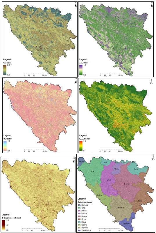
According to the pedological map of Bosnia and Herzegovina, 88 % of the territory is dominated by automorphic, humus-accumulative soils (black soil on limestone and dolomite-calcomelanosol, classes of cambic soils, classes of eluvial-illuvial soils), while hydromorphic soils (epigleyic, hypogleyic and classes of fluviatile and fluviogley soils) account for 12 % of the territory of Bosnia and Herzegovina (Burlica & Vukorep, 1980; Resulović et al., 2008).
The soil erosion protection coefficient (Xa) describes the protective effect of vegetation or artificial cover against erosive forces and is determined by land use. Soil erosion protection coefficient (Xa) are classified into 7 categories, ranging from 0.50 (Mixed Forest and dense brushes) to 1.00 (Denudated unarable lands – badlands) (Figure 2). In this study, data for estimating the Soil erosion protection coefficient (Xa) was obtained using several sources, including the European Environment Agency, Disco Map, The European Commission's science and knowledge service – Forest Mapping, Global Forest Change, High-Resolution Global Maps of 21st – Century Forest Cover Change, land use data from LUISA (Land Use based Integrated Sustainability Assessment Modeling Platform, LUCAS model, etc.), and the 1:200,000-scale map of real forest vegetation for the territory of Bosnia and Herzegovina. The spatial distribution of this coefficient is largely related to the land use method. Analyzing the basic categories of land use on the territory of Bosnia and Herzegovina, and according to the situation in 2024 and the enumerated cartographic and geospatial bases, it is clearly visible that forests cover 46.34 %, shrubs and bushy vegetation 15.92 %, pastures 6.33 %, arable and diverse agricultural areas 26.60 %, while areas without cover (bare, etc.) comprise 2.11 % of the territory of Bosnia and Herzegovina (LUISA Base Map, 2024). Analysis of the spatial distribution of land use as a determining factor of the intensity of water erosion indicates that the influence increases from the main Dinaric Mountain ridges of Bosnia and Herzegovina towards the north and south, with the fact that it is most pronounced in the north, and somewhat less in the south of Bosnia and Herzegovina. This is clearly evident in the spatial distribution of the soil erosion protection coefficient (Xa). Given that forests cover almost 47 % of the territory of Bosnia and Herzegovina, and that forest vegetation protects the soil from erosion in various ways depending on the type of forest, structure, and parent substrate, the spatial distribution of actual forest vegetation was analyzed.
Lower altitudes feature various forest types depending on the climate: climatogenic oak and holm oak forests in the Mediterranean region; honeysuckle and hornbeam forests in the sub-Mediterranean region; forests typical of moderate continental climates; and mulberry and cherry forests in continental climate areas. Phytocenoses of willows, black and white poplars, as well as oak and black alder, are characteristic of lowland areas.
The coefficient of type and extent of erosion (φ) indicates the intensity of the active erosion processes. Coefficients of type and extent of erosion (φ) are classified into 10 categories, ranging from 0.10 (land surface without visible erosion effect; mostly crop fields and areas under woods or perennial crops such as meadows and pastures, etc.) to 1.00 (basin area fully affected by gully and deep erosion) (Figure 2). In this study, the estimation of the Coefficient of type and extent of erosion (φ) was based predominantly on field recognition of erosion intensity in watersheds across the territory of Bosnia and Herzegovina during the period 2017 - 2024. In addition, when updating the Coefficient of type and extent of erosion (φ), current aerial photos of Bosnia and Herzegovina were used, as well as current satellite images (Google Earth, Bing Maps, World Imagery, etc.), with a note that all data were updated and processed as of 2024. When determining the Coefficient of type and extent of erosion (φ), satellite or digital orthophoto images (regardless of resolution) were not used exclusively, because these images do not provide all the necessary information to accurately define this parameter. A satellite or orthophoto image can show land use (cultivated, uncultivated, pastures, forests, etc.) in parts of the basin, but cannot reveal the state of dominant erosion processes on those surfaces (such as surface erosion and its forms, line erosion and its forms), nor the characteristics of sediment in the riverbeds of the mapped basin, because the characteristics of the sediment in the river bed represent one of the indicators of the state of erosion in the basin (type of sediment, granulometric characteristics, dominant deep or lateral erosion, fluvial floods, etc.). If the determination of these parameters were based solely on satellite and digital orthophotos, the Coefficient of type and extent of erosion (φ) would not be adequately assessed, and the resulting erosion map would fail to reflect the actual erosion conditions in the watershed. In this context, a topology of erosion polygons was created on 1:25,000-scale maps during field reconnaissance (watersheds in Bosnia and Herzegovina). Each polygon was assigned a coefficient of the type and extent of erosion (φ), which was later converted into raster data. The complex geomorphological characteristics (vertical relief dissection) of Bosnia and Herzegovina greatly hindered movement across the terrain and observation of erosion processes. During field reconnaissance, major obstacles included areas contaminated with mines and unexploded ordnance.
Cartographic representation of this parameter clearly shows the significant influence of land use and geological-geomorphological characteristics of watersheds on its value and spatial distribution.
The Imean – mean slope of the research area (m/m) – represents the relief slope values. Using GIS analysis based on a 20x20 m DEM, several relief slope categories were identified across Bosnia and Herzegovina, with their respective area percentages: 0 - 2° (14.72 %), 2 - 5° (6.44 %), 5 - 12° (18.68 %), 12 - 32° (46.20 %), 32 - 55° (13.63 %), and over 55° (0.33 %). In terms of the influence of slopes on erosion processes, those exceeding 10° are particularly significant, especially in cultivated areas. Steep slopes are typically found in mountainous areas, where vegetation cover and the pedological substrate are often significantly degraded. The high slope values further contribute to the intensification of surface and linear erosion.
The Erosion Map of Bosnia and Herzegovina shows five categories of erosion intensity: I category – Excessive erosion, II category – Intensive erosion, III category – Medium erosion, IV category – Slight erosion, and V category – Very slight erosion (Figure 3). The state of erosion based on the distribution of specific erosion categories in Bosnia and Herzegovina is presented in Table 3.

|
Table 3. The state of erosion on the territory of Bosnia and Herzegovina according to the distribution of erosion intensity categories. |
||
|
Erosion category |
F (km2) |
F (%) |
|
I - Excessive erosion |
909.81 |
1.78 |
|
II - Intensive erosion |
1,415.11 |
2.76 |
|
III - Medium erosion |
5,714.21 |
11.15 |
|
IV - Slight erosion |
12,745.66 |
24.87 |
|
V - Very slight erosion |
30,465.54 |
59.44 |
If erosion categories I, II, and III are considered to represent stronger erosion, it can be concluded that they occur on 15.69 % of the territory of Bosnia and Herzegovina. Areas under categories IV and V cover 84.31 % of the territory of Bosnia and Herzegovina. Notably, category V accounts for the largest share, mainly because it extensively covers forested areas, karst terrain, agricultural fields, and broad lowlands along the major tributaries of the Sava River.
An analysis of the first erosion category (category I – excessive erosion), characterized by the strongest intensity of surface erosion and the presence of numerous linear forms (rills, gullies) of varying degrees of morphological development, reveals numerous localities in Bosnia and Herzegovina where these erosion processes dominate. This category is relatively widespread due to the specific geological structure characterized by erodible rocks, steep valley slopes, and weak forest cover (especially along riverbanks), which, combined with high precipitation, creates favorable conditions for surface erosion and the development of numerous linear erosion forms.
In addition, this category includes numerous examples of linear forms along the edges of large karst fields composed of dolomite. Examples of excessive erosion are visible in forests subjected to intensive exploitation, in numerous quarries, surface coal mines, and other locations where mineral raw materials are intensively extracted. In some cases, surface erosion has diminished on some of these areas due to vegetation growth, but pronounced linear forms (shallow or deep) remain, retaining their potential and, during intense rainfall, represent the main sources of sediment.
The second category of erosion (category II – intensive erosion) includes areas affected by intense processes of surface and linear erosion. Notable examples include heavily degraded forests (oak forests on southern exposures or certain conifer forests on diabase-chert formations) and bare slopes with numerous gullies. This category also includes areas that have been intensively cultivated (nearly 80 % of the land), located on slopes exceeding 15°. The prevalence of strong erosion categories in relation to arable land can primarily be attributed to the limited extent of intensively cultivated land in the hilly-mountainous regions of Bosnia and Herzegovina. In these areas, agricultural production has been significantly reduced, often to minimal levels, accompanied by a marked population decrease. This outcome reflects the cumulative socio-economic transformations of the past forty years, particularly the war, which has caused profound direct and indirect consequences. The only exceptions are areas closer to the main economic centers (Bihać, Banja Luka, Mostar), where villages have been preserved, larger households remain, or former state agricultural properties have been granted under concession, allowing continued intensive agricultural production.
The largest part of the territory of Bosnia and Herzegovina belongs to the fifth erosion category (V category – very slight erosion). This category is characterized by very weak processes of surface erosion and weakly expressed traces of linear erosion. Spatially, it corresponds to areas under forests and pastures, or areas that, due to their location and the impossibility of agricultural use, have gradually become overgrown with tall grasses and weeds. This category also corresponds to the areas of typical karst relief – vast parts of western Bosnia and Herzegovina, high and low Herzegovina, Romanija and other parts where typical karst relief has developed. Very weak erosion encompasses the vast plains in northern Bosnia and Herzegovina, characterized by gentle slopes, primarily due to the presence of thick pedological cover (often hydromorphic soils), and the prevalence of land parcels managed through systems of lateral drainage channels. Forests constitute the primary factor contributing to the extensive spatial coverage of the very weak erosion category. Given that forested areas encompass nearly 50 % of the territory of Bosnia and Herzegovina, it is evident that this land cover type plays a decisive role in the predominance of this erosion category. Certainly, it should be emphasized that not all forests fall within this erosion category. Their classification depends primarily on the type of forest communities, degree of preservation, and their structural composition, as factors that significantly influence water runoff and the conditions for the development of erosion processes. Additionally, it depends on the slopes on which the forests are located, as well as the presence of linear forms, whether naturally formed (gullies) or resulting from improper forest exploitation.
The third erosion category (category III – medium erosion) manifests as surface erosion with mostly shallow, individual linear forms, appearing in certain degraded forests or pastures on non-resistant ground. However, it is predominantly expressed as surface and subtle linear erosion on arable land on slopes up to 10°, and in some cases even steeper slopes, provided they are intensively cultivated (orchards, vineyards, etc.). In the northern lowlands of Bosnia and Herzegovina, where agricultural production has been preserved (two-field and three-field crop rotation), this category is the most prevalent, meaning that all areas suitable for agriculture are cultivated to the highest extent. Gentler slopes, usually up to 10°, are cultivated, while steeper slopes are converted into smaller orchards or grasslands and are seldom intensively farmed. This category also includes cultivated areas of covered karst areas, regardless of their karst base, and particularly where surface watercourses are present (surface hydrography).
The fourth erosion category (category IV – slight erosion), characterized by surface erosion and the presence of shallow rills on non-resistant ground, is found in many locations across the northern, central, southwestern, and southeastern parts of Bosnia and Herzegovina. These areas typically include forests with poor structure, grasslands, and scorched fields. In most cases, surface erosion intensity remains low due to the preservation of relatively intact pedological cover over the parent substrate, supporting natural grass and low vegetation. Areas that were once cultivated have often become neglected and scorched fields, where pioneer species of wild forest vegetation are beginning to establish.
In general, northern Bosnia and Herzegovina, in addition to the large share of very slight erosion, also demonstrates a significant presence of the medium erosion category. It may therefore be concluded that erosion intensity in this region is generally higher than in the central parts of the country. However, it is important to recognize that these areas are intensively cultivated (agricultural region of Bosnia and Herzegovina) and that erosion processes are often implicit (hidden) on these surfaces. Despite the predominance of surface erosion, linear erosion forms are reestablished annually and subsequently erased through cultivation practices. Likewise, these areas serve as significant sources of sediment, as evidenced by the numerous torrential flows recorded in this region. In contrast, the central part of Bosnia and Herzegovina, characterized by its geological substrate, relief features, and extensive forest cover, largely falls within the categories of weak and very weak erosion. Therefore, it is important to note the presence of areas classified under excessive, strong, and moderate erosion. In many locations, surface erosion processes are pronounced, often reaching strong or excessive levels. The prevalence of linear erosion features stands out as a dominant sediment source, feeding numerous mixed-type torrential flows. The southern, southwestern, and southeastern parts of Bosnia and Herzegovina (including western Bosnia and both western and eastern Herzegovina) are predominantly composed of limestone formations, dominated by karst relief (karst surfaces and karst fields), covered by either grass or forest vegetation, and dominated by erosion processes of very weak and low intensity, with a smaller share of stronger categories of erosion.
The territory of Bosnia and Herzegovina is divided into several major river basins. Within the Black Sea Basin these include the Kupa (Korana), Una, Vrbas, Ukrina, Bosna, Drina, and several smaller basins within the immediate basin of the Sava River. In the Adriatic Sea Basin, the main river systems are the Cetina, Neretva, and Trebišnjica, along with smaller direct catchments draining into the Adriatic Sea (Figure 2).
By analyzing the Erosion Map of Bosnia and Herzegovina, the representation values of certain categories and the mean coefficient of erosion (Z) were determined for each basin (Table 4).
|
Table 4. The state of erosion in the larger basins of Bosnia and Herzegovina according to the representation of categories of erosion intensity and the mean value of the erosion coefficient (Z) for each watershed in km2. |
||||||
|
River basin |
I Erosion category |
II Erosion category |
III Erosion category |
IV Erosion category |
V Erosion category |
Zmean |
|
Korana |
9.15 |
89.82 |
201.87 |
134.39 |
266.28 |
0.38 |
|
Una |
95.29 |
122.35 |
877.06 |
1,330.90 |
4,974.44 |
0.22 |
|
Vrbas |
41.00 |
141.78 |
682.81 |
1,552.95 |
3,884.85 |
0.22 |
|
Ukrina |
53.57 |
62.22 |
271.29 |
297.20 |
798.38 |
0.30 |
|
Bosna |
197.94 |
312.97 |
1,167.79 |
2,530.70 |
6,273.10 |
0.24 |
|
Drina |
163.64 |
168.39 |
779.24 |
1,920.97 |
4,154.74 |
0.25 |
|
Immediate basin of the Sava River |
5.47 |
78.07 |
356.25 |
560.00 |
3,044.87 |
0.15 |
|
Cetina |
91.10 |
33.22 |
260.18 |
1,097.33 |
2,406.08 |
0.21 |
|
Neretva |
200.32 |
279.94 |
928.71 |
2,442.19 |
3,498.63 |
0.28 |
|
Trebišnjica |
46.48 |
122.75 |
176.20 |
839.42 |
1,064.14 |
0.26 |
Overall, the data on the percentage representation of certain erosion categories in the analyzed larger basins show that the potential conditions for the development and intensification of erosion processes (primary factors of erosion) significantly influence the distribution of erosion intensity categories across individual basins. Differences in the representation of erosion intensity categories are also evident when comparing basins draining into the Black Sea with those belonging to the Adriatic Sea basin. These findings are further confirmed by the average erosion coefficient (Z) values, which are significantly higher in river basins draining into the Black Sea. This difference can primarily be attributed to variations in geological and geomorphological characteristics, land use practices (such as arable farming), and other factors that contribute to the greater prevalence of excessive, intensive, and medium erosion categories.
5. CONCLUSIONS
The erosion map of Bosnia and Herzegovina provides a clear insight into the spatial distribution of all five categories of erosion intensity. By analyzing the erosion intensity across the territory of Bosnia and Herzegovina, it is possible to conclude that, based on the potential conditions for the development and intensification of erosion processes, the intensity of erosion largely corresponds with the geological structure (non-resistant and impermeable rocks), relief characteristics (such as slopes and exposure), land use types, spatial distribution of the population and their primary activities, as well as other factors. In this context, there is a clear spatial representation of erosion categories IV, and V on 84.31 % of the territory of Bosnia and Herzegovina, and categories I, II and III on 15.69 %. In addition, the values of the representation of certain categories of erosion intensity in larger watersheds in Bosnia and Herzegovina are shown, as well as the values of the average erosion coefficient (Zmean) for each basin area.
The mean value of the erosion coefficient (Z) for the basins is the basic value for the calculation of the average annual gross erosion (W) and the annual sediment yield (G). The paper shows the values of the mean coefficient of erosion (Z), which enables the practical use of the data provided by the Erosion Map of Bosnia and Herzegovina.
Therefore, the Erosion Map of Bosnia and Herzegovina enables quick and easy information on the spatial distribution of erosion intensity categories. Forty years after the creation of the first Erosion Map of Bosnia and Herzegovina in 1985, the erosion map presented here represents an important step forward. in the methodological and cartographic sense, a way to indicate the importance of the intensity of erosion processes in Bosnia and Herzegovina, and to present the results to other disciplines (water management, agriculture, forestry, environmental protection, spatial planning, etc.) in which the area of Bosnia and Herzegovina is in the focus of professional or scientific research.
According to the trends that are already clear, it is more and more certain that the state and scale of the intensity of erosion in Bosnia and Herzegovina will change dynamically, not only under strong anthropogenic influence, but also under the increasingly significant influence of climate change, as one of the more important primary factors of the intensity of water erosion. In this sense, the Erosion Map of Bosnia and Herzegovina defined the initial state and created the basis for data on soil erosion to become compatible with the data of the surrounding countries, which based the creation of their national erosion maps on the Erosion Potential Method (EPM) or one of the known empirical methods.
Acknowledgments
The authors would like to acknowledge the support of the Institute for Water Management LTD Bijeljina for enabling the use of the geology and soil database, climatology database, as well as other relevant databases.
REFERENCES
- Agency for Statistics of Bosnia and Herzegovina, 2016. Census of population, households and dwellings in Bosnia and Herzegovina 2013. Sarajevo.
- Amini, S., Rafiei, B., Khodabakhsh, S., & Heydari, M., 2010. Estimation of erosion and sediment yield of Ekbatan Dam drainage basin with EPM, using GIS. Iranian Journal of Earth Sciences, 2(2), 173-180.
- Bakker, M., Govers, G., Kosmas, C., Vanacker, V., van Oost, K., & Rounsevell, M., 2005. Soil erosion as a driver of land use change. Agriculture, Ecosystems & Environment, 105(3), 467–481, https://doi.org/10.1016/j.agee.2004.07.009.
- Bezak, N., Borrelli, P., Mikoš, M., Jemec Auflič, M., & Panagos, P., 2023. Towards multi-model soil erosion modelling: An evaluation of the erosion potential method (EPM) for global soil erosion assessments. Catena, 234(10), 75-96, https:// doi.org/10.1016/j.catena.2023.107596.
- Borrelli, P., Robinson, D.A., Fleischer, L.R., Lugato, E., Ballabio, C., Alewell, C., Meusburger, K., Modugno, S., Schütt, B., Ferro, V., Montanarella, L., & Panagos, P., 2017. An assessment of the global impact of 21st century land use change on soil erosion. Nature Communications, 8, 1-13, https://doi.org/10.1038/ s41467-017-02142-7.
- Burlica, C., & Vukorep, I., 1980. Soil map of Bosnia and Herzegovina in scale 1:500,000. Sarajevo.
- Cerdan, O., Govers, G., Le Bissonnais, Y., van Oost, K., Poesen, J., Saby, N., Gobin, A., Vacca, A., Quinton, J., Auerswald, K., Klik, A., Kwaad, F.J.P.M., Raclot, D., Ionita, I., Rejman, J., Rousseva, S., Muxart, T., Roxo, M.J., & Dostal, T., 2010. Rates and spatial variations of soil erosion in Europe: A study based on erosion plot data. Geomorphology, 122(1-2), 167–177. https:// doi.org/ 10.1016/j.geomorph.2010.06.011d.
- de Vente, J., & Poesen, J., 2005. Predicting Soil Erosion and Sediment Yield at the Basin Scale: Scale Issues and Semi-Quantitative Models. Earth-Science Reviews, 71, 95-125, http://dx.doi.org/10.1016/j. earscirev.2005.02.002.
- de Vente, J., Poesen, J., & Verstraeten, G., 2005. The application of semi-quantitative methods and reservoir sedimentation rates for the prediction of basin sediment yield in Spain. Journal of Hydrology, 305(1-4), 63-86, https://doi.org/ 10.1016/ j.jhydrol.2004.08.030.
- de Vente, J., Poesen, J., Arabkhedri, M., & Verstraeten, G., 2007. The sediment delivery problem revisited. Progress in Physical Geography, 31(2), 155-178, https://doi.org/10.1177/0309133307076485.
- de Vente, J., Poesen, J., Bazzoffi, P., Van Rompaey, A., & Verstraeten, G., 2006. Predicting catchment sediment yield in Mediterranean environments: the importance of sediment sources and connectivity in Italian drainage basins. Earth Surface Processes and Landforms, 31(8), 1017-1034, https://doi.org/ 10.1002/esp.1305.
- de Vente, J., Poesen, J., Verstraeten, G., Van Rompaey, A., & Govers, G., 2008. Spatially distributed modelling of soil erosion and sediment yield at regional scales in Spain. Global and Planetary Change, 60(3-4), 393-415, https://doi.org/10.1016/ j.gloplacha.2007.05.002.
- Dragičević, N., Karleuša, B., & Ožanić, N., 2017. Erosion Potential Method (Gavrilović method) sensitivity analysis. Soil and Water Research, 12(1), 51-59, https://doi.org/10.17221/27/2016-SWR.
- Dragičević, N., Karleuša, B., & Ožanić, N., 2018. Modification of erosion potential method using climate and land cover parameters. Geomatics, Natural Hazards and Risk, 9(1), 1085-1105, https://doi.org/10.1080/19475705.2018.1496483.
- Dragićević, S., Novković, I., & Milutinović, M., 2009. The erosion intensity changes in Zaječar municipality. Glasnik srpskog geografskog društva, 89(4), 3-10, https://doi.org/10.2298/ GSGD0904003D.
- Drešković, N., 2015. Spatial distribution of annual rainfall in Bosnia and Herzegovina using Spatial Kriging Interpolator. Geografski pregled, 36, 95-107.
- Drešković, N., & Mirić. R., 2017. Thermal regime of annual air temperature in Bosnia and Herzegovina. Revija za Geografijo, 12(1), 109-120.
- Eisazadeh, L., Sokouti, R., Homaee, M., & Pazira, E., 2012. Comparison of empirical models to estimate soil erosion and sediment yield in micro catchments. Eurasian Journal of Soil Science, 1(1), 28-33.
- Fanetti, D., &Vezzoli, L., 2007. Sediment input and evolu tion of lacustrine deltas: the Breggia and Greggio rivers case study (lake Como, Italy). Quaternary International, 173-174, 113-124, https://doi.org/ 10.1016/j.quaint.2007.02.008.
- Gavrilović, S., 1972. Engineering of Torrents and Erosion, Journal of Construction (Special Issue). Belgrade, 1-292, (In Serbian).
- Globevnik, L., Holjević, D., Petkovšek, G., & Rubinić, J., 2003. Applicability of the Gavrilovic method in erosion calculation using spatial data manipulation techniques, Erosion prediction in Ungauged Basins: Integrating methods and techniques. Proceedings of Symposium HS01, 279, Sapporo, 224-233.
- Gocić, M., Dragićević, S., Radivojević, A., Martić Bursać, N., Stričević, L., & Đorđević, M., 2020. Changes in Soil Erosion Intensity Caused by Land Use and Demographic Changes in the Jablanica River Basin, Serbia. Agriculture, 10(8), 345. https://doi.org/10.3390/agriculture10080345.
- Haghizadeh, A., Teang Shui, L., & Godarzi, E., 2009. Forecasting sediment with erosion potential method with emphasis on Land use changes at basin. Electronic Journal of Geotechnical Engineering, 14, 1-12.
- Hrvatović, H., 2006. Geological guidebook trough Bosnia and Herzegovina. Geological Survey of Federation Bosnia and Herzegovina Sarajevo. 1-172.
- Jetten. V., de Roo, A. & Favis-Mortlock D., 1999. Evaluation of field-scale and catchment-scale soil erosion models. Catena, 37(3-4), 521-541, https:// doi.org/10.1016/S0341-8162(99)00037-5.
- Jetten, V., Gouvers G. & Hessel R., 2003. Erosion models: quality of spatial predictions. Hydrological Processes, 17(5), 887-900, https:// doi.org/10.1002/hyp.1168.
- Kostadinov, S., Zlatić, M., Dragićević, S., Novković, I., Košanin, O., Borisavljević, A., Lakićević, M. & Mladjan, D., 2014. Anthropogenic influence on erosion intensity changes in the Rasina river watershed-Central Serbia. Fresenius Environ-mental Bulletin, 23(1a), 254-263.
- Lazarević, R., 1984. Bilans nanosa Jablaničke akumulacije. Erozija-stručno informativni bilten, 12.
- Lazarević, R., 1985. Soil erosion map of Bosnia and Herzegovina in scale 1:25000. Institute for water management Sarajevo: Final Report for 1985 year, 2-43, (In Serbian).
- Lazarević, R., 1991. Bilans nanosa Zvorničke akumulacije. Erozija-stručno informativni bilten, 18.
- Lazarević, R., 2010. Erozija u Bosni i Hercegovini. Beograd: Želind, 1-387.
- Leh, M., Bajwa, S., & Chaubey, I., 2013. Impact of land use change on erosion risk: An integrated remote sensing, geopraphic information system and modeling methodology. Land Degradation & Development, 24(5), 409-421, https://doi.org/ 10.1002/ldr.1137.
- LUISA Base Map, 2024. European Commission, JRC Data Center.
- Milanesi, L., Pilotti, M., Clerici, A., & Gavrilovic, Z., 2015. Application of an improved version of the erosion potential method in Alpine areas. Italian Journal of Engineering Geology and Environment, 1, 17-30, https://doi.org/10.4408/IJEGE.2015-01.O-02.
- Milevski, I., 2008. Estimation of soil erosion risk in the upper part of Bregalnica watershed Republic of Macedonia, based on digital elevation model and satellite imagery. Proceedings from the 5th International conference on geographic information systems, Fatih University, Istanbul, 351-358.
- Milevski, I., Aleksova, B., Lukić, T., Dragićević, S. & Valjarević, A., 2024. Multi-hazard modeling of erosion and landslide susceptibility at the national scale in the example of North Macedonia. Open Geosciences, 16(1), 1-17, https://doi.org/ 10.1515/geo-2022-0718.
- Panagos, P., Borrelli, P., Poesen, J., Ballabio, C., Lugato, E., Meusburger, K., Montanarella, L., & Alewell, C., 2015. The new assessment of soil loss by water erosion in Europe. Environmental Science & Policy 54, 438-447, https://doi.org/ 10.1016/j. envsci.2015.08.012.
- Resulović, H., Ćustović H., & Čengić, I., 2008. Sistematika tla/zemljišta (nastanak, svojstva i plodnost). Sarajevo: Poljoprivredno-prehrambeni fakultet, Univerzitet u Sarajevu.
- Spalevic, V., Djurovic, N., Mijovic, S., Vukelic-Sutoska, M., & Curovic, M., 2013. Soil erosion intensity and runoff on the Djuricka River Basin (north of Montenegro). Malaysian Journal of Soil Science, 17, 49-68.
- Stefanović, V., Beus, V., Burlica, Č., Dizdarević, H., & Vukorep, I., 1983. Ekološko-vegetacijska rejonizacija Bosne i Hercegovine. Sarajevo: Šumarski fakultet, Univerziteta u Sarajevu, Posebna izdanja,17.
- Tazioli, A., 2009. Evaluation of erosion in equipped basins: Preliminary results of a comparison between the Gavrilovic model and direct measurements of sediment transport. Environmental Geology, 56(5), 825-831, https:// doi.org/10.1007/s00254-007-1183-y.
- Tošić, R., Dragićević, S. ,& Lovrić, N., 2012a. Assessment of soil erosion and sediment yield changes using erosion potential method - Case study: Republic of Srpska - BiH. Carpathian Journal of Earth and Environmental Sciences, 7(4), 147-154, https://doi.org/10.2298/GSGD18021500 2L.
- Tošić, R., Todorović, D., Dragićević, S., Bikit, I., Forkapić, S., & Blagojević, B., 2012b. Radioactivity and measurements of sediment deposition rate of the Drenova reservoir (B&H). Nuclear Technology & Radiation Protection, 27(1), 52-56, https://doi.org/10.2298/NTRP1201052T.
- Tošić, R., Dragićević, S., Bikit, I., Forkapić, S., Mrđa, D., Todorović, N., & Blagojević, B., 2012c. Estimating the soil erosion and deposition rate using 137Cs tracer method in the catchment of Drenova reservoir - (B&H). Nuclear Technology & Radiation Protection, 27(3), 247-253, https:// doi.org/ 10.2298/NTRP1203247T.
- Tošić, R., Lovrić, N., & Dragićević, S., 2019. Assessment of the impact of depopulation on soil erosion: Case study-Republika Srpska (Bosnia & Herzegovina). Carpathian Journal of Earth and Environmental Sciences, 14(2), 505-518, https:// doi.org/10.26471/cjees/2019/014/099.
- Tošić, R., & Dragićević, S., 2024. Chronological development of the Erosion Potential Method. Belgrade: Serbian Geographical Society, 1-189, (In Serbian).
- van Rompaey, A., & Govers, G., 2002. Data quality and model complexity for regional scale soil erosion prediction. International Journal of Geographical Information Science, 16(7), 663-680, https:// doi.org/10.1080/13658810210148561.